
The Geospatial Semester at Washington Liberty High School
Ryan Miller, GIS teacher at Washington Liberty High School, and his students share insights from his class at the 2024 ESRI Users’ Conference.
Geospatial Semester students sweep awards at ESRI Conference
Students in JMU’s renowned Geospatial Semester were big winners in the Map Gallery competition at the ESRI International User’s Conference. The maps, based on students’ final projects in their dual enrollment geospatial technology class, took first, second and third place in the teen category at the conference, attended by 18,000 geospatial professionals from around the world.
Geospatial Semester impacts students at Loudoun Valley High School
Loudoun Valley High School integrated the Geospatial Semester program with a class for exceptional learners to teach geospatial science to a broader range of students. Read more about their efforts in ESRI’s Spring 2021 ARCNEWS article: Virginia High School Helps More Students Expand Their Analytical Capabilities.
Blue Raster interns share their experience with ArcGIS StoryMaps
Joe Nadonley and Kelly Motzko, recently shared a behind-the-scenes look at their first storytelling experience with Blue Raster and with the new ArcGIS StoryMaps Beta. As geographic studies majors at The Pennsylvania State University and James Madison University respectively, both have advice for fellow students and educators in secondary and higher education.
JMU participates in NSF’s STEM for All Video Showcase highlighting innovation in STEM education
Dr. Bob Kolvoord, JMU's interim provost, is featured in the 2018 STEM for All Video Showcase funded by the National Science Foundation. The presentation, entitled “Neural Impacts of Classroom-based Spatial Education,” examines how the innovative use of classroom technology through JMU’s Geospatial Semester affects participating students’ critical thinking and brain structure.
The Geospatial Semester in Virginia: A Story of Success in K-12 GIS Education
The GSS has been in operation for 13 years, and seen more than 3,500 students gain college credit through the program. More than 450 students graduated from the program in the 2017-2018 school year, and 150 had the opportunity to present their projects to GIS analysts at the National Geospatial Intelligence Agency.
Students embrace GIS for project-based learning
Schools around the world are teaching with GIS software, and students are reacting with enthusiasm. Chris Bunin’s GIS students at Albemarle High School in Charlottesville, Virginia, had a lot to say about how learning to map changed their thinking.
Geospatial Semester Program receives international exposure
During the Plenary Session of the 2012 ESRI International User’s Conference, Geospatial Semester students from Washington-Lee High School took the stage to present their technical skills and their ability to solve real-world problems in front of 14,000 professionals. Check out the videos of their presentations here:
Geospatial Semester student wins 2011 National Council for Geographic Education map contest
Eric Cowi, a 2011 graduate of the Loudoun Academy of Science in Sterling, VA, and a JMU Geospatial Semester dual enrollment student, was a winner at the National Council for Geographic Education (NCGE) map contest, held in conjunction with the NCGE Annual Meeting in Portland, OR. Eric won the K-12 Analysis award for his project on Analyzing the Optimal Location of Solar Farms in the Northeast Corridor. This was a remarkable achievement for Thomas and his teacher, Mr. Duke Writer.
Geospatial Semester student wins 2010 National Council for Geographic Education map contest
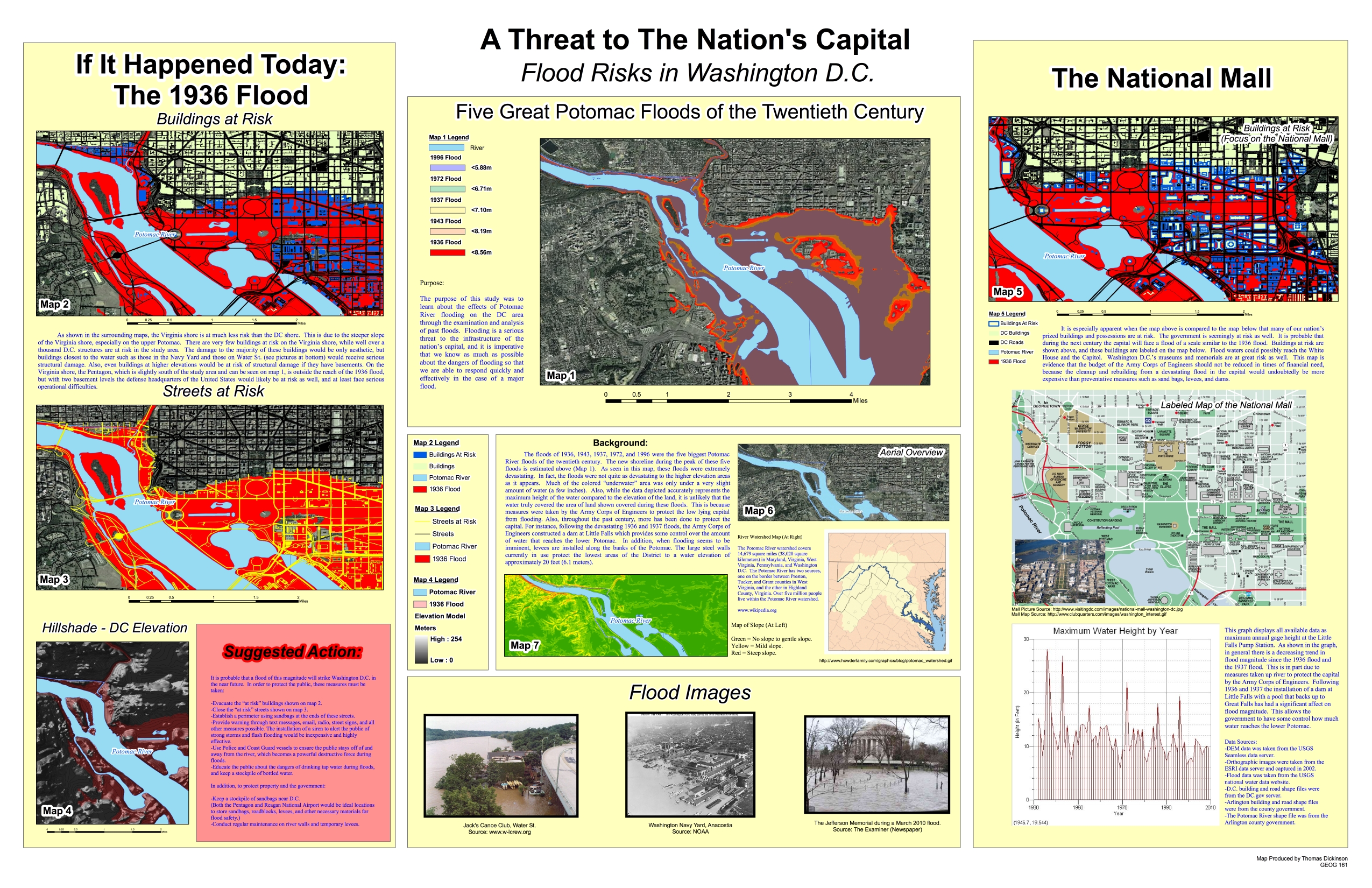
Thomas Dickinson, a 2010 graduate of Washington-Lee High School in Arlington, VA, and a JMU Geospatial Semester dual enrollment student, was a big winner at the National Council for Geographic Education (NCGE) map contest, held in conjunction with the NCGE Annual Meeting in Savannah. GA. Thomas won all of the awards in the K-12 category (Communications and Cartography) and his project was selected as the overall winner in Communication across all categories for his project on Flood Risks in Washington, DC. This was a remarkable achievement for Thomas and his teacher, Mr. Ryan Miller.
Journal Articles