
ISAT students build an aquatic drone to monitor local lake health
News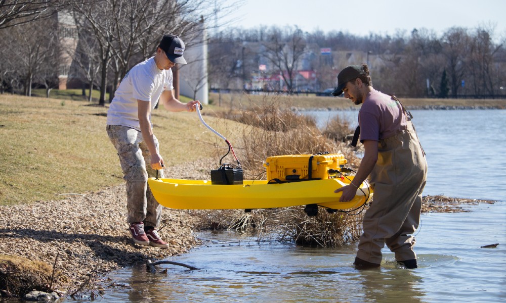
SUMMARY: ISAT students designed and built an aquatic drone equipped with sonar, GPS and a custom control system to map the depth and contours of two local lakes—data that now helps guide real-world environmental decisions.
Integrated Science and Technology majors Miles McIntyre (‘25) and Nathaniel Horner (‘25) made waves with their capstone research project — an aquatic drone. The drone is a custom-built, watertight, lightweight kayak outfitted with sonar, GPS, and a custom control system that integrates navigation, power, and remote communication.
McIntyre and Horner used the device to map the depth and contours of Lake Shenandoah and Newman Lake — two bodies of water with different roles but shared environmental concerns.
The project began in 2023 when Dr. Tom Benzing, an ISAT professor (now emeritus), connected with Earth Systems Management, a company that develops aquatic drones for monitoring coastal and inshore waters. After visiting ESM’s lab on Virginia’s Eastern Shore, he saw an opportunity to adapt the technology for use in small inland lakes.
ISAT major Joe Dunnigan (‘23) laid the groundwork for studying Lake Shenandoah, launching what would become a multi-year effort. McIntyre and Horner expanded the project’s scope and took it into the field. “We picked up where he left off,” Horner said.
Dr. Robert Brent, an ISAT professor, advised the project alongside Benzing. “Tom started the project before he retired and is still very involved,” Brent said.
“I’ve retired, but I’ve always enjoyed the time I spent advising capstone students on projects like this one,” said Benzing.
The team visited ESM’s lab in Wachapreague, Virginia, where they observed a drone build and test run. “They showed us the parameters needed to map out a lake and how to run the drone,” McIntyre said. Horner added that while many of the components, like sonar and GPS, are widely available, the guidance from ESM was essential in helping them troubleshoot and fine-tune their system.
Horner led the electronics and software development. McIntyre handled the physical construction, troubleshooting everything from waterproofing to mounting the thrusters. “Fitting components together and sealing everything properly took trial and error — but that’s what made it fun,” McIntyre said.
With faculty support, the students entered a formal collaboration with ESM, including a non-disclosure agreement that allowed them to access and adapt design details of the company’s hydro drones. “We signed an NDA, so we can't discuss everything in detail,” McIntyre explained.
Once the drone was complete, McIntyre and Horner headed to Lake Shenandoah, just outside Harrisonburg, for a test run. Once a cold-water trout lake fed by underground springs, it’s now warmer and shallower — impacted by development, sediment buildup and dam repairs.
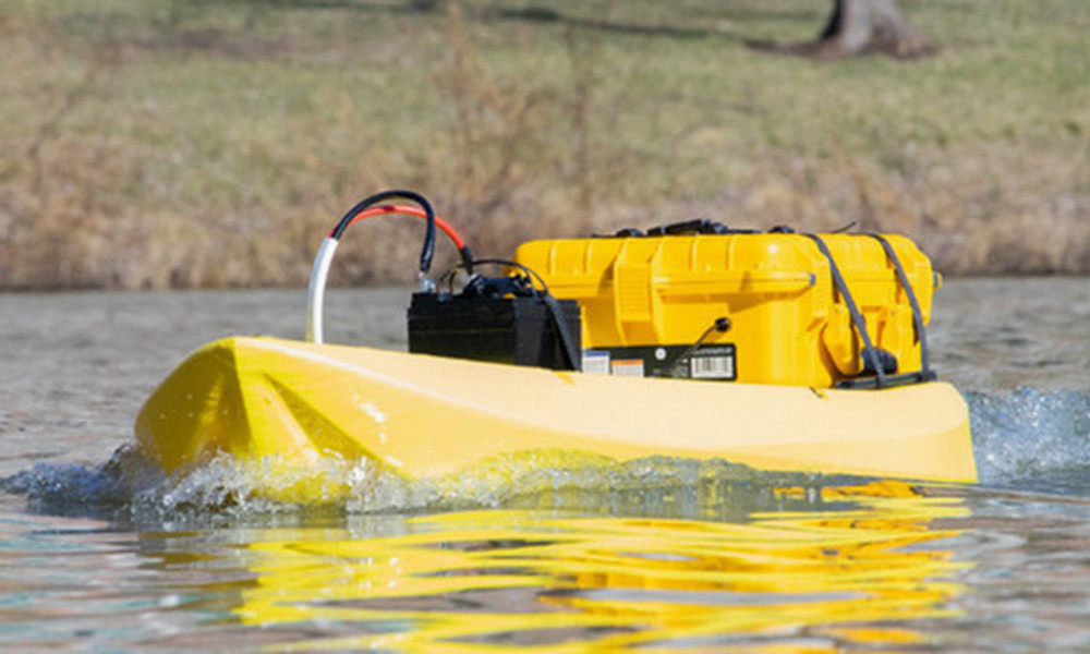
The student-built aquatic drone skims across Newman Lake to collect depth and contour data for environmental monitoring.
The team collected data and processed it using ReefMaster, a mapping software. The software converts thousands of GPS and sonar readings into high-resolution bathymetric maps that show the depth and shape of the lakebed. Using contour lines, these maps help the Virginia Department of Wildlife Resources visualize the underwater landscape, monitor changes and plan for future management.
“Seeing the first map appear on the screen was one of those moments where it all came together,” said Horner. “It was the physical manifestation of months of work.”
After the successful maiden voyage, they expanded their scope to include Newman Lake, which was constructed in 1967, to manage runoff and prevent flooding. Over the years, the lake has accumulated sediment, impairing its ability to retain water. By producing a bathymetric map, McIntyre and Horner helped JMU Facilities Management determine whether dredging is necessary. “We can save them time and money without draining the entire lake just to find out,” McIntyre said.
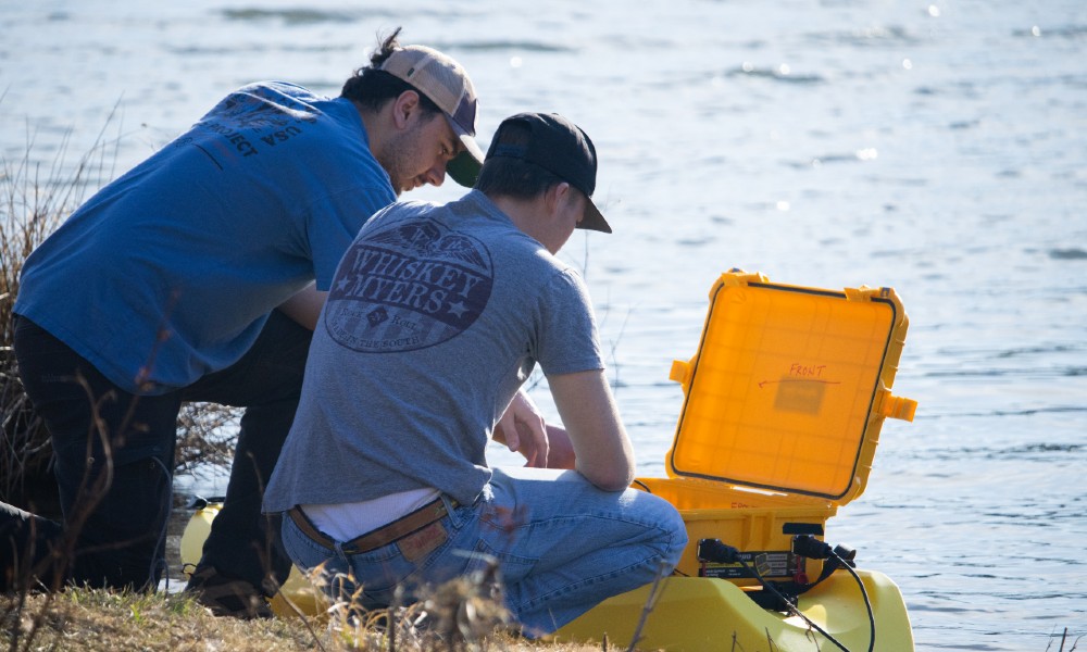
McIntyre and Horner review the drone’s control system to ensure it's ready to collect bathymetric data from Newman Lake.
The team provided their data and maps to DWR and JMU Facilities Management to support ongoing monitoring of the lakes’ ecosystems.
Like many ISAT capstones, this project didn’t begin or end with a single team. It’s part of a larger, evolving initiative spanning multiple years, with different students contributing to its progress. McIntyre and Horner built on the work of a previous student, bringing the drone from concept to reality. Now, they’re passing it off to the next capstone team. “We’ve already talked to another student who’s interested in picking up where we left off,” Horner said.
In ISAT, students hand off ideas, tools and data from one year to the next, enabling long-term impact and a more enriching learning experience. “We could add water quality sensors next or use the drone in coastal areas to locate oyster beds,” Brent said. It’s a flexible platform, and there’s a lot of potential.”
ISAT capstone projects serve as a culmination of four years of interdisciplinary learning. Students work with industry professionals and are tasked with solving real-world problems while managing budgets and timelines.
“ISAT is all about taking a problem and trying to bring together all of the scientific understanding, regardless of discipline, and addressing it with appropriate technology,” Benzing said.