
Mapping a Legacy: 20 Years of the Geospatial Semester
News
SUMMARY: Celebrating its 20th anniversary, the Geospatial Semester is one of JMU’s longest-running and most impactful outreach programs.
In 2005, James Madison University launched a small but ambitious pilot program: a partnership with four high schools across Virginia that allowed seniors to earn college credit while solving real-world problems using geospatial technology. Now celebrating its 20th anniversary, the Geospatial Semester has become one of JMU’s longest-running and most impactful outreach programs.
“We started the Geospatial Semester to provide an opportunity for students in their final year of high school to have an experience that would energize them through the school year,” said Dr. Bob Kolvoord, interim provost and co-founder of the program.
“Too many students ‘retire in place’ after their college applications are submitted,” Kolvoord said. “We wanted to re-engage them with meaningful work — geospatial technologies in particular — and help them prepare for what comes next: higher education or the workforce, where learning is more project-focused and far less about high-stakes testing.”
Launched during a time when Virginia’s Standards of Learning (SOL) testing dominated public education, the Geospatial Semester was designed to give teachers a break from test preparation and support more inquiry-driven learning in the classroom.
Offered through a dual enrollment model, the Geospatial Semester allows high school students to remain at their home campuses while learning Geographic Information Systems, Global Positioning Systems, and other spatial technologies. Supported by local instructors and mentored by JMU faculty, students apply these tools to community-based projects, earning JMU credit in the process.
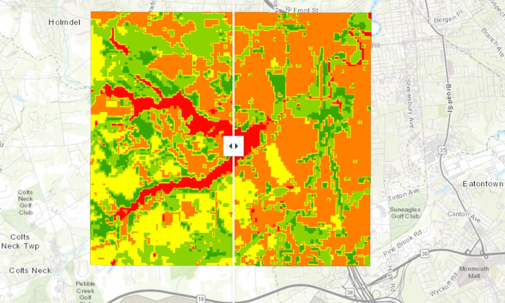
Amy Key, a Geospatial Semester student from Langley High School, modeled the flood risk in Lincroft, New Jersey, by combining terrain, hydrology, and land use data from 1995 and 2020.
The curriculum is designed to be flexible and student-centered. Each course culminates in an extended research project of the student’s choosing, giving them agency over what they explore and how.
Project topics have ranged from environmental and energy issues to public safety and land-use planning. In one award-winning effort, a student examined development patterns and flood risk in a coastal region of New Jersey by modeling how water would move through the landscape. In another project, a group of students used Virginia DMV data to analyze the effect of speed cameras on traffic accidents across the state.
The program continues to grow steadily. Next year, the Geospatial Semester will be active in 31 schools across 10 Virginia districts, a 50% increase in enrollment from the previous year. Kolvoord credits much of this growth to sustained district-level investment. “I think the increase was due to school districts continuing to see the value of the GSS for their students.
While student outcomes are a key measure of success, the program’s impact on teachers is equally profound. “Teachers have shared a variety of positive aspects of being involved,” Kolvoord said. “Several teachers remark that the GSS lets them rediscover the power of inquiry-based learning and reenergizes their teaching. Some have even stayed in the classroom after their nominal retirement date because the GSS was such a satisfying class.”
Students, too, leave transformed. Many discover career paths and disciplines they had never even considered. “They talk about the revelation of the power and ubiquity of these technologies,” Kolvoord said. “We’ve seen a strong flow of students from the GSS into JMU’s Geography and IA majors. In fact, 15 to 20 percent of Geography majors come from the GSS each year.” Alumni of the program now work across the geospatial industry in both the government and private sectors.
The Geospatial Semester has also earned national and international recognition. It has been replicated at institutions including Pacific University in Oregon, the University of Redlands in California, and Beijing Normal University. It was featured in the plenary session of the 2025 ESRI Education Users Conference and received a Special Achievement in GIS award.
Faculty have conducted research on the program’s long-term impact, including studies showing improvements in students’ spatial thinking and problem-solving abilities. “We think the case for the impact of the GSS is very strong,” Kolvoord said. “We’d love to see it spread more broadly across the U.S. and other countries.”
Nearly two decades in, the Geospatial Semester remains a national model for mentored dual enrollment. It combines academic credit with hands-on learning, teacher empowerment, and meaningful collaboration between the university and the community.
The Geospatial Semester is supported by JMU's College of Integrated Science and Engineering, the School of Professional and Continuing Education, and esri.