
Reviving Old Mosul: 3D Modeling Aids Safe Clearance in Iraq
By Erin Atkinson, Marc Dennehy, and Craig Locke [ Tetra Tech ]
CISR Journal
This article is brought to you by the Center for International Stabilization and Recovery (CISR) from issue 27.3 of The Journal of Conventional Weapons Destruction available on the JMU Scholarly Commons and Issuu.com.
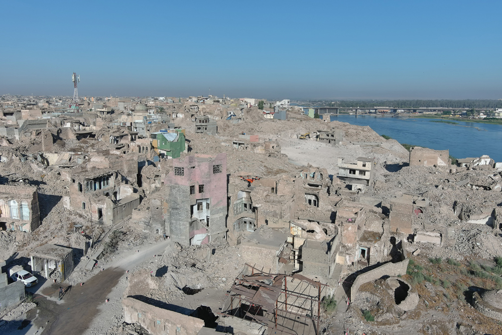
Under the 2014–2017 Islamic State of Iraq and Syria (ISIS) occupation, the Old City of Mosul, Iraq, served as a headquarters for the self-proclaimed caliphate. ISIS produced, stored, and transited money, modern munitions, weapons, and improvised explosive devices (IEDs) through the city’s ancient stone streets. Since 2019, the U.S. Department of State has contracted Tetra Tech to survey and clear IEDs and unexploded ordnance (UXO) in Ninewa, Anbar, and Kirkuk Governorates. In 2022, with the cooperation of the Iraq Directorate of Mine Action (DMA), the Iraqi State Bureau of Antiquities and Heritage (SBAH), and the International Alliance for the Protection of Heritage in Conflict Areas (ALIPH), main clearance and rehabilitation efforts in Mosul shifted focus to the Old City. Old Mosul was divided into two large hazardous areas for systematic clearance.
To approach the immense and technically challenging task of clearing the Old City efficiently, effectively, and safely—without compromising the city’s rich cultural history—Tetra Tech created a 3D model using aerial photogrammetry to quantify and visualize the scope and scale of the project. This technique allowed the team to precisely calculate volumes of debris, strategically plan operations and safe displacement areas, and methodically document the current state of archeological and culturally significant properties within the Old City. The model permitted Tetra Tech to remotely characterize damaged buildings, measure street widths with precision, identify structures reoccupied by internally displaced persons (IDPs), and establish visibility into areas beyond the safe reach of cleared pathways—only wide enough for a pair of feet.
This article presents a case study of how Tetra Tech leveraged 3D modeling to create a phased, data-driven site clearance plan for the Old City of Mosul, including two historic and culturally significant properties, the Al-Masfi Mosque and Al Tahera Church.
Lessons from this approach can expedite clearance planning and operations in urban and emerging conflict zones by quantifying project scale and granting foresight into suspected and confirmed hazardous areas. Further analysis is needed to evaluate the efficacy of this approach in comparison to traditional international mine action standards (IMAS) clearance practices.
The Old City of Mosul
The Old City of Mosul, situated on the banks of the Tigris River in Nineveh Governorate, has remained a center for culture and commerce throughout the millennia.1 Since the Neolithic Age (6,000 BCE), civilizations have risen and fallen, each leaving their physical record along the ancient city’s warren of narrow streets.2 The life-giving Tigris-Euphrates River system brings water from Turkey and Iran into Iraq, creating a rich agricultural and economic development environment aptly named the “Fertile Crescent.”3
ISIS Battle for Mosul
In June 2014, after waging war across the Nineveh Plains, ISIS entered Mosul, declared a caliphate from the top of the Al Nuri Mosque, and occupied the city for three years. The militants used the ancient stone buildings of the Old City as courts, banks, jails, stores, and factories for creating explosives and weapons. They also persecuted and massacred religious and ethnic minorities—forcing thousands of families to flee—and vandalized significant religious and cultural sites throughout the city.4 On 1 November 2016, the battle for the liberation of Mosul began.
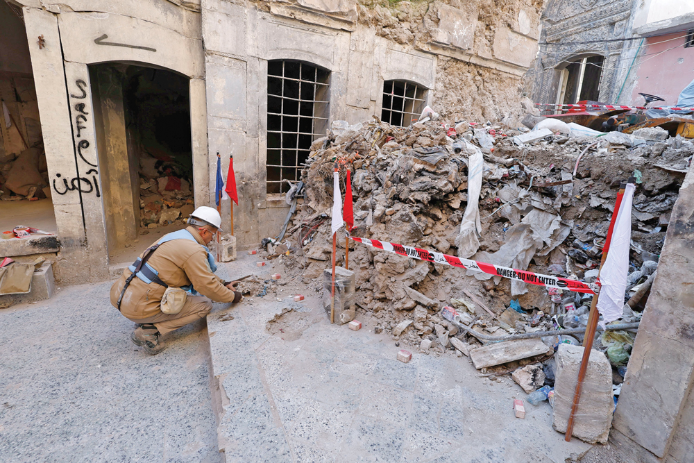
In preparation for close guerilla warfare, ISIS militants cut tunnels through walls of ancient stone buildings, carried and detonated suicide belts, and laid explosive booby traps in homes and basements. Iraqi and Coalition airstrikes and artillery bombardments pummeled Old Mosul until June 2017.5 The eight months of war in the Old City left behind a deadly legacy of UXO and IEDs in a heavily damaged, dense urban environment. To this day, these explosive hazards remain buried under piles of rubble left from the airstrikes, sometimes as deep as 10–12 meters.
Six Years Later
During the conflict and occupation, from 2014–2017, more than one million people fled Mosul and the western Nineveh Governorate.6 In 2022, government-run IDP camps began closing nationwide. Families returned to Old Mosul to find their community filled with millions of metric tons of rubble and thousands of explosive remnants of war (ERW) piled atop, inside, and under their homes.
Despite the risk, families began reoccupying corners of the Old City and clearing passageways for foot and motorcycle traffic through the narrow ancient streets.
With civilians eager to return to their community and the presence of many ancient and religious properties among the rubble, the DMA required a systematic, controlled clearance approach that respected the sanctity of the Old Mosul neighborhood and honored its deep history. Previous efforts at clearance in the Old City were limited to UXO spot clearance tasks.
Clearance in the Old City
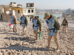
Since 2019, Tetra Tech has performed humanitarian mine action (HMA) and munitions response services in Iraq. Tetra Tech clears explosive hazards from critical infrastructure, vital economic centers, and areas of cultural and historical importance. Tetra Tech also trains and mentors local national demining capacity to facilitate Iraqis in gaining agency and longevity in the explosive hazard removal and HMA sphere.
In 2022, the Iraq DMA tasked Tetra Tech with beginning clearance of the Old City. The initial clearance polygon was assessed as 281,000 square meters along the western bank of the Tigris River, from Old Bridge in the south to Fifth Bridge in the north. However, this square meter figure only represented a simple, two-dimensional footprint in a dense, urban area full of multistory structures, most of which included basements below street level.
Tetra Tech needed to find a way to quantify the realistic three-dimensional (3D) size and scope of the clearance task to provide an accurate level of effort, estimate resource needs, and optimize schedule efficiency.
Another unique facet of clearance in the Old City is the presence of culturally important and historically significant properties, such as mosques, churches, ancient bathhouses, and archaeological sites. The Old City itself is on the United Nations Education, Science, and Culture Organization’s (UNESCO) tentative list of World Heritage sites.7
The conservation of these important structures is paramount to preserving the historic character of the Old City. Our team liaises closely with the SBAH to facilitate documentation of historic structures and items of historical or cultural significance found during clearance. All Tetra Tech staff working in Old Mosul have received SBAH training to identify and report culturally sensitive items, and SBAH staff are on-site daily during clearance operations.
Aerial Photogrammetry, 3D Modeling, and Mine Action
On average, manual mine clearance activities can clear between 10–12 square meters daily, depending on the conditions and operator.8,9 The clearance of Old Mosul requires highly technical clearance of complex explosive devices in a very dense urban landscape—streets full of destroyed buildings, immense piles of rubble, and a population actively returning to their community.According to the Geneva International Centre for Humanitarian Demining (GICHD), real-time drone technology surveillance can aid security operations and disaster management,10 save human lives, and improve operational efficiencies in demining.11 Nonetheless, flying unmanned aerial vehicles (UAV) is often restricted due to their association with military operations, dated legislation, and privacy concerns.12
In the past, photogrammetry and multispectral imaging have successfully bolstered survey and mapping in agriculture, food science, healthcare, and emergency and resource management.13 Combining spectral imagery with spatial information has been shown to outperform spectral imagery alone, and models can be validated with confidence using pixel-to-pixel comparison.14
| Clearance Operations |
|
| Imagery and Data Management |
|
| Explosive Ordnance Risk Education (EORE) |
|
| Figure 1. Operational efficiencies improved by the 3D model. Courtesy of Tetra Tech. |
3D Model of Old Mosul
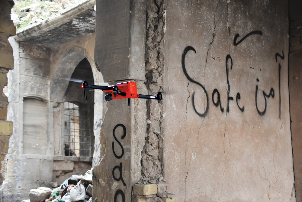
In need of a simple way to quantify the immensity of clearing Old Mosul, Tetra Tech adapted their routine processes for employing remote-controlled UAVs as a non-technical survey (NTS) and reconnaissance tool to capture and pair imagery with geospatial information in a 3D model. This model improved efficiencies in clearance operations, information management, and explosive ordnance risk ordnance education (EORE), as seen in Figure 1.
First, Tetra Tech UAV operators systematically employed UAVs and photogrammetry to capture more than 15,000 orthorectified high-resolution images of the Old City. Local government officials required Iraqi intelligence officers to be present during all wide-area UAV data collection; therefore, close schedule coordination was essential.
Multiple operators captured images in forty hours of flight time spread over two weeks, requiring strict data management processes to coordinate and align image capture efforts. After capturing and uploading the imagery, Tetra Tech’s information and database manager reviewed the collected data, removing extraneous photos while ensuring maximum usability.
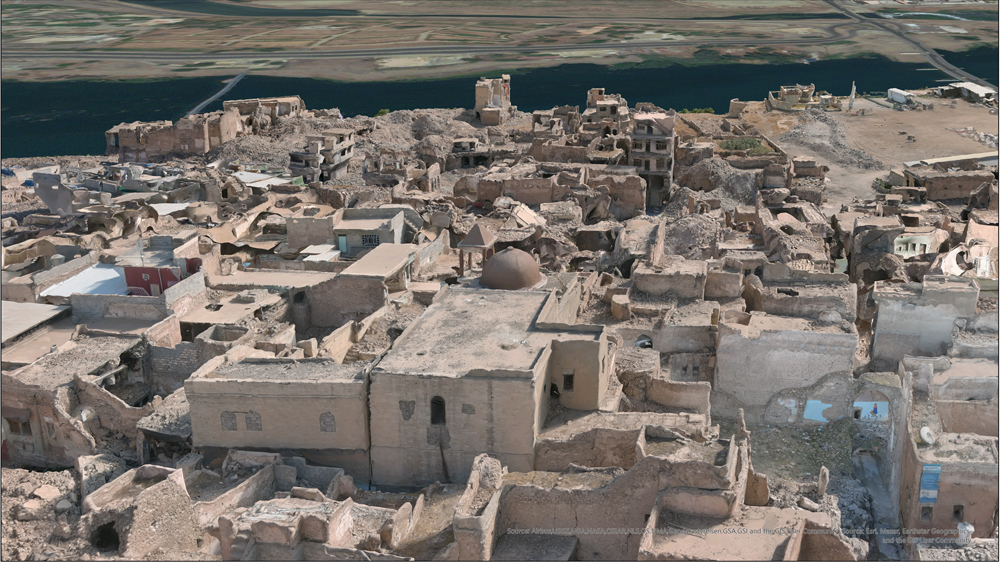
Relevant images were uploaded and stitched together using Pix4Dmapper, a software that identifies key tie points between photos to create a 3D point cloud of the urban landscape. The information and database manager then migrated the point cloud into ArcGIS to create a spatially accurate, photorealistic, and interactive 3D model of the entire clearance area, accurate to within 20 centimeters. Data processing of the images took approximately one hundred hours.
The locations of identified explosive hazards and other important items were entered into the 3D model, including georeferenced photos, size, and attribute data. These data enhance the spatially accurate, interactive environment for analyzing distribution patterns of UXO and IEDs, allowing the routine reassessment of explosive threats. This unique dataset may also be useful to military historians who want to study the tactics and outcomes of the Battle for Mosul.
Tetra Tech used the resultant model to:
- Revise the scale of the problem. By leveraging the model, Tetra Tech reassessed the initial estimate of 281,000 square meters for clearance. Our analysis determined that the actual clearance effort encompassed more than 985,000 square meters, in addition to clearing over one million cubic meters of rubble. This refined scope takes into consideration the three-dimensional characteristics of the urban landscape, enabling more informed decisions regarding resource allocation, scheduling, and budgeting.
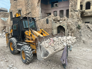
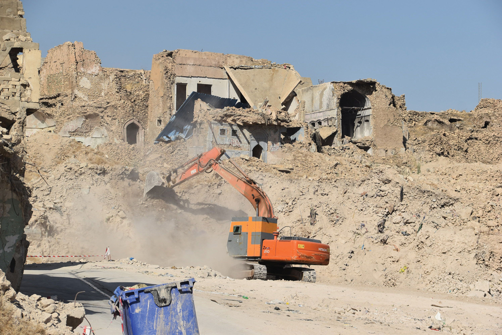
- Measure the environment. The model was employed to compute the volumes of extensive rubble piles, gauge street widths, determine building heights, and establish boundaries within the Old City. Leveraging these data, our operations can develop a well-structured, data-driven, and efficient clearance strategy. The model aids in optimizing mechanical asset utilization, pinpointing access points for tight spaces, coordinating the movement of substantial quantities of cleared rubble, positioning flexible staging areas, and identifying priority sites for clearance.
- Characterize damaged buildings. The model’s photorealistic representation allows Tetra Tech to gain insight into areas that are typically inaccessible, such as the tops and undersides of roof overhangs or the interiors of unstable structures that are unsafe to enter physically. Moreover, Tetra Tech will continually refresh the model with new imagery as clearance progresses, turning it into a dynamic dataset that evolves over time.
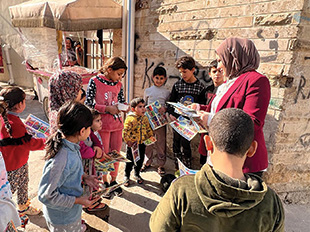
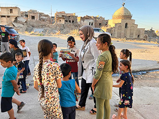
- Customize EORE and community outreach. The model allows our community liaison officers to prioritize areas for targeted EORE by identifying houses and buildings that appear to be reoccupied. The clearest indication of reoccupation was the appearance of rugs and laundry on rooftop terraces, items visible from the air. Furthermore, the model assists in tailoring the content of EORE to concentrate on the specific types of explosive hazards present in the immediate area.
Key specifications of the model for each phase of the workflow include planning for clearance, flying the UAVs, building the model, and clearing explosive hazards (see Figure 2). As demonstrated in Figure 2, the model enables Tetra Tech to reassess the scope of the clearance effort, redistribute current resources, and shorten the projected timeline for project completion. Additionally, Tetra Tech will collect ongoing imagery updates as the clearance progresses. This approach will continuously refine and adapt our clearance strategy to address emerging priorities.
|
Planning for Clearance
|
|
Flying the UAVs
|
|
Building the Model
|
|
Clearing Explosive Hazards
|
|
Figure 2. Model specifications corresponding to the clearance workflow. Courtesy of Tetra Tech. |
Revitalizing Historic Properties
When the DMA issued the Old City clearance task in 2022, they identified two historic, culturally significant properties as top priorities for clearance within the larger polygon: the Al Tahera Catholic Church and the Al Masfi Mosque. Both properties received funding for rehabilitation work that could commence as soon as clearance of explosive hazards was complete. Using the 3D model, Tetra Tech quickly created a workable strategy for assessing rubble and resource needs for optimized clearance operations at these two properties.
Operations in and around these historic buildings require constant liaison with local religious leaders and government agencies. The 3D model serves as a digital benchmark for the current condition of these important structures and facilitates local stakeholder engagements with UNESCO and the ALIPH Foundation, who are funding the rehabilitation of these sites.
Al Tahera Catholic Church
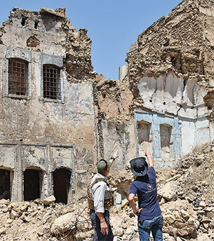
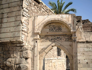
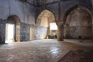
UNESCO remarked that the Al Tahera Catholic Church is woven into the history of the Old City as “a symbol of the diversity that has been the story of Mosul for centuries.”15 The church opened in 1862 after three years of construction. The marble stonework is highly carved, including ornate columns, arches, hand-crafted stone tombs, and crosses carved on the walls and in the courtyard.
Post-conflict, vast amounts of rubble filled the area within the church walls, and large pieces of rubble risked the stability of the surrounding structure. The 3D model was used to establish the boundaries of the Al Tahera clearance effort, allowing our team to estimate rubble volumes, prioritize staging areas, and plan a smart, phased approach to clearance.
In just under two months, Tetra Tech cleared over 400 explosives from 2,000 square meters at Al Tahera Catholic Church, including part of the Bishop’s house, the surrounding walls, and parish houses. Explosive hazards removed from the church compound include over sixty IEDs and IED components, air-dropped improvised munitions (ADIMs), improvised projectiles, suicide vests, UXO, and small arms ammunition. Using data from the 3D model, Tetra Tech optimized resource utilization and reduced clearance time by 25 percent compared to initial level of effort (LOE) estimates. As of 2023, the site is fully cleared, and UNESCO is rehabilitating the church’s interior, employing stonemasons to hand carve marble to replace damaged sections of the décor.
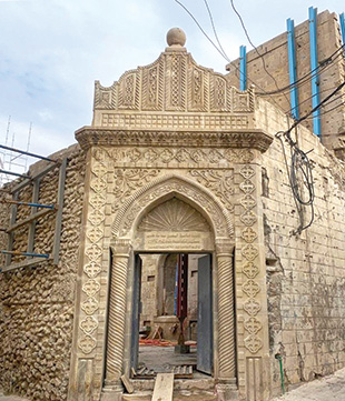
Al-Masfi Mosque
Al-Masfi Mosque is considered by many to be the heartbeat of the Old City. According to the ALIPH Foundation, Al-Masfi “stands on the site of the oldest mosque in Mosul,” first consecrated in 638 CE, and the current building dates to the 19th century.16 Over the entry gate and along the sahn (courtyard) entrance wall are carved and painted inscriptions referring to the ancient origins of the mosque. Inside the prayer hall, the stone mihrab, huge granite columns on large pediments, and original woodwork attest to the age and enduring character of the building.
Our demining teams used the 3D model to plan operations, assess conditions, and formulate a work plan. The high-resolution orthorectified images of the mosque’s roof facilitated building clearance, removing the need to erect scaffolding and place a human deminer in an unsafe work environment. The model also enabled Tetra Tech to brief the ALIPH Foundation,17 the organization funding ongoing archeological excavations and rehabilitation efforts at Al Masfi.18
Tetra Tech cleared over 700 explosive hazards from 1,000 square meters within the mosque compound in just under three weeks, including ADIMs, conventional and improvised UXO, suicide vests, and small arms ammunition.
3D Modeling and Mine Action Learning
Although Tetra Tech has currently cleared a total of 324,000 square meters of the Old City (which already exceeds the original polygon issued by the DMA), we estimate that 985,000 square meters remain to be cleared as of July 2023. An accurate understanding of how much work is left to complete can help inform Tetra Tech operations and help the DMA plan and schedule future resource allocation.
This 3D model serves as a digital time capsule of a city in its current post-conflict state and has the potential to be used globally to understand broader battle tactics used in cities; the widespread and lasting effects of war on urban landscapes; how a city rebuilds itself, and the post-conflict condition of historic properties, such as important religious centers or archaeological sites.
Tetra Tech posits that 3D modeling can expedite explosive ordnance detection, clearance, and debris disposal in urban settings by informing safe and effective UXO clearance planning and operations, optimizing visibility into potentially hazardous areas prior to personnel movement, and strengthening relevance and strategic delivery of EORE.
These data can inform long-term development strategies, improve the understanding of resource gaps within a returning population, and inform efforts to revitalize culturally significant properties. Modeling can map and codify recently contaminated areas in conflict zones with little to no historical or personal accounts of the hazards and facilitate stakeholder education on cleared areas prior to designing physical and social development projects.
While this type of modeling has not previously been employed in large-scale urban clearance efforts, the benefits of 3D modeling in enhancing data-driven demining clearance operations is clear. Although this project represents a singular, positive example of applying photogrammetry and modeling in the urban HMA sector, conducting additional comparative research could provide quantifiable insights into the time-saving advantages of 3D modeling when applied to traditional survey and clearance methods. Tetra Tech intends to continue updating the model to gain further clarity on these beneficial practices.
 Erin Atkinson is a Tetra Tech project manager and geophysicist with fifteen years of experience in munitions response on CONUS and OCONUS projects. Since 2019, she has managed the US Department of State’s Worldwide Weapons Destruction Support Services Task Order in Iraq, providing humanitarian mine action services across the country. She has degrees in archaeology, geography, and environmental science from the University of Texas at Austin and sits on the United Nations’ International Mine Action Standards (IMAS) Review Board.
 Marc Dennehy is a Tetra Tech Task Order Leader with over ten years of experience in munitions response. Since 2019, he has provided in-country management and technical oversight for the US Department of State’s Worldwide Weapons Destruction Support Services Task Order in Iraq, providing humanitarian mine action services across the country. Dennehy holds degrees in civil law and criminal justice from Ireland’s University College Cork and is a graduate of the British military’s Royal School of Military Engineering, Defence Explosive Ordnance Disposal, Munitions and Search Training Regiment.
 With a decade of experience as a Royal Engineer Geographic Technician, Craig Locke deployed globally, including operational duties in Afghanistan. In 2016, he transitioned to the civilian sector, where he contributed to planning 5G, dark fiber, and fiber-to-the-home networks in the United Kingdom. With Tetra Tech, Locke worked as a GIS Analyst on the US Department of State Conventional Weapons Destruction Program in Syria and now manages GIS initiatives in Iraq—combining military precision with cutting-edge technology.
| Erin Atkinson Tetra Tech 1320 N. Courthouse Rd, Suite 600 Arlington, VA 22201 Erin.atkinson@tetratech.com |
| Stay updated | |||