
The Deadly Legacy of World War II in Alaska
By Ken Rutherford, PhD [ Professor of Political Science, James Madison University ]
CISR Journal
This article is brought to you by the Center for International Stabilization and Recovery (CISR) from issue 26.1 & 2 of The Journal of Conventional Weapons Destruction available on the JMU Scholarly Commons and Issuu.com
Japanese Occupation of the Aleutian Islands
In the middle of the Bering Sea—closer to Japan than the continental United States and more than 1,000 miles from Alaska’s largest city, Anchorage—sit the Alaskan islands of Attu and Kiska. It was the summer of 1942, nearly six months after Japan’s surprise attack on Pearl Harbor, that Japanese forces invaded these islands in what was some of World War II’s most brutal fighting and use of explosives.
The Japanese military high command had decided to occupy Attu and Kiska to fulfill several goals:
- To prevent American use of the Alaskan archipelago for mounting offensive operations (Attu is only 720 miles from Japan’s Northern Territories islands)1
- To drive a wedge between US and Soviet insular possessions
- To establish bases for air operations against Alaska and the west coasts of Canada and the United States.
When Japanese forces occupied Attu and Kiska, it was the first time since the War of 1812 that American soil had been held by foreign forces. The islands are in the far western part of the Aleutian Islands chain. Most Americans were not aware of the Aleutians until the Japanese invasion, but the chain of islands was considered a valuable strategic piece of real estate by both Japanese and American leaders. One year later, Allied forces retook the islands in bloody fighting that resulted in a deadly legacy of thousands of explosive remnants of war (ERW), unexploded ordnance (UXO), landmines, and booby traps, some of which may still infest the soil.
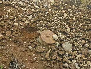
Possibly unexploded shell largely buried in the sift soil. Seen northwest of Gun A, six-inch gun battery, North Head. Image courtesy of the author/Museum of the Aleutians.
The major obstacle for both armies was the Aleutians’ isolated geography, characterized by difficult weather. Among all World War II battlefields, the Aleutian Islands were some of the wildest and most inhospitable. Terrific winds blow at more than 100 miles per hour, perpetual fog hinders vision and orientation, and there are almost no trees on the islands. The temperature drops below freezing in winter and seldom exceeds sixty degrees in summer, and the islands have as many as 250 rainy days a year.
Over the fourteen-month occupation, an estimated 8,600 Japanese troops were deployed to Attu and Kiska, which they heavily fortified in anticipation of inevitable American offensive operations to recapture the islands. The Japanese prediction was correct: in responding to the invasion, the US military underwent the first mass airlift in its history. Within thirty-six hours of the islands’ occupation, 2,300 American troops and tons of supplies and weapons were flown to Nome, on the western edge of the Alaska mainland.
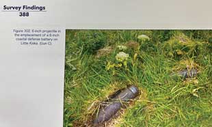
A six-inch projectile in the emplacement of a six-inch coastal defense battery on Little Kiska (Gun C). Image courtesy of the author/Museum of the Aleutians.
Buildup of the US Army’s forces in Alaska continued until 94,000 troops were stationed across thirteen newly-constructed bases, including Cold Bay at the western end of the Alaska Peninsula. Due to US testing and stockpiling of weapons on Cold Bay, humanitarian threats from UXO became an issue.2 One former Cold Bay inhabitant remembers that “[p]eople were always whizzing around on three-wheelers, and kids could test their luck screwing around with the buried World War II munitions that still dot the landscape.” Additionally, children were remembered as “playing on actual World War II-era torpedoes abandoned on the beach.”3
North of Cold Bay and the Aleutian Islands sits the Pribilof Islands group, which is where the US Army built a long-range aid to navigation (LORAN) station, controlling the Bering Sea approaches to the Alaskan coast. Stationed on the island of Saint Paul, US soldiers placed landmines around the village buildings on the chance that the Japanese would invade.4
Attu: Operation Landgrab
Attu is about forty miles long and twenty miles wide, and its highest peak rises more than 3,000 feet above the sea. On 11 May 1943, Attu would be the US Army’s first island amphibious landing of the war.5 The soldiers landed in dense fog and were unopposed. Sergeant Hamlin of the 7th Scout Company recalled how “It was easy to get completely lost in the fog. It was easy to get completely turned around in the thick moving mist that made everything vague … the freezing cold and fog had been a harder enemy to fight than the Jap[anese]. Ninety percent of the Scout Company and three-fourths of the 7th Reconnaissance Troop suffered from severe exposure.”6
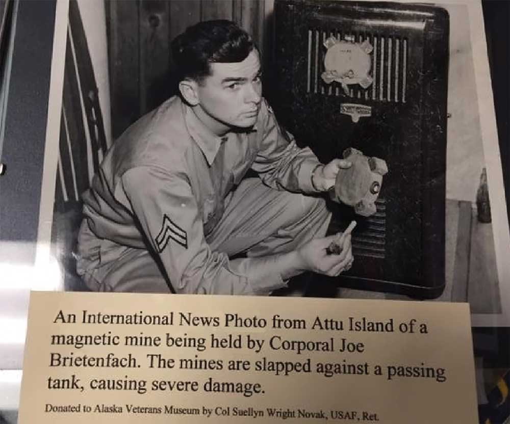
Image courtesy of Alaska Veterans Museum.
From the beginning, Japanese troops were on the defensive and made the most of the terrain for that purpose. Rather than organizing beach defenses, they chose to defend the high ground at the northern end of Massacre Bay at 3,000 to 4,000 yards inland, and in the valleys leading to Chichagof Harbor, where the Japanese had established a strong defensive position.7 In general, the Japanese forces employed the same tactics they had used in the South Pacific. While Attu and Kiska lacked the foliage and tropical growth provided by the islands in the South Pacific, the Japanese prepared excellent camouflaged positions and dotted the terrain with foxholes and two-man caves protected by light machine guns, mortar positions, and emplaced landmines.
On the morning of 29 May 1943, nineteen days after American troops landed, the Japanese staged a massive “Banzai” charge with around 800 Japanese soldiers attacking the American lines. Before the charge, nearly 500 Japanese wounded soldiers committed suicide or were killed by their own troops rather than being allowed to surrender.8 The Japanese inflicted heavy casualties as they overran the frontline American positions, but most were quickly killed by the American troops.9 By the following morning, the battle for Attu was over. The American victory in Attu was bloody and costly: “549 Americans were killed, and more than 3,200 were wounded or suffered from exposure or other battle injuries. Of the approximate 2,600 Japanese troops on the island, only 28 were taken prisoner. All others had honored the Samurai code of death.”10
The Battle of Attu ranks as the second deadliest battle in the Pacific Theater (in proportion to the number of troops engaged), closely falling behind Iwo Jima. The casualties incurred during the invasion of Attu were appalling, with Americans suffering 3,248 casualties, roughly 25 percent of the invading force. Of these, 541 men were killed. Of the Japanese forces, 2,350 men were counted by American burial parties, and hundreds more were presumed already buried. The Japanese fought to virtually the last man.11
Kiska: Operation Cottage
After the bloody repatriation of Attu, the US Army turned its sights 205 miles east to the island of Kiska. Approximately thirty miles long and seven miles wide, the island has a shoreline that includes few beaches suitable for landing, and the better of the available beaches were controlled by entrenched Japanese defensive positions. The Japanese defenders augmented the island’s favorable defensive geographical features—steep, hilly terrain and a profusion of valleys and caves—with machine gun positions, newly constructed tunnels and roads, and landmines.
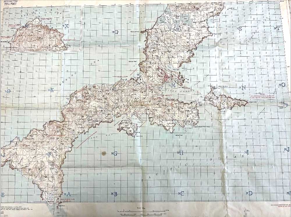
Former classified Kiska Map - Pre-Allied invasion of Japanese occupied Kiska Island. "War Department, Corps of Engineers, US Army," July 1943. One of the few if not only map of landmines emplaced on US soil by a foreign Army. The US Army suffered landmine casualties on the island. Image courtesy of the author/Museum of the Aleutians archives.
In retaking the island, US forces subjected Kiska to a heavy pre-invasion bombardment. The first bombing attacks were carried out 11 June 1943 by four B-24s out of Cold Bay.12 A total of 424 tons of bombs were dropped on Kiska in July. During the same month, a strong naval task force lobbed 330 tons of shells onto the island.13
“The surrounded Japanese garrison found a small window of opportunity in the Allies’ seamless ring of ships to quickly and quietly evacuate the island in a dense fog. On 28 July, the Japanese garrison evacuated 5,200 Japanese soldiers on nineteen boats that formed the rescue armada. The evacuation was completed in just fifty-five minutes. Nothing much was left behind except a few dogs, a corpse of a soldier who had died recently of natural causes, a litter of landmines and booby traps, and some bombs preset to blow at the rate of one a day.14 An after action report by US Army Intelligence noted that the south end of Kiska was found to be sprinkled liberally with mines and booby-traps. One of the favorite methods was to wire an M-93 mine upside down to about thirty blocks of TNT, thus increasing the concussion area.”15
Canadian artillery officer Captain William Kirby, who was part of the Kiska recapture, shared how the enemy’s ability to slip away “through the ‘impenetrable’ Allied naval blockade, which was really a triple blockade of seaplanes, submarines and coastal torpedo boats escorted by destroyers, had been a daring and brilliant feat.”
Additionally, the Kiska evacuation had been carried out almost three weeks before the planned Allied landing. Since the Japanese departure went undetected, US forces continued to bomb and shell the abandoned island. In the ensuing month, more than 2,700 tons of bombs were dropped on the deserted island, including “two of the navy’s bombardments that were the heaviest in Pacific naval warfare.”17 More than 300 tons of explosives were dropped in a single day alone: 4 August 1943.
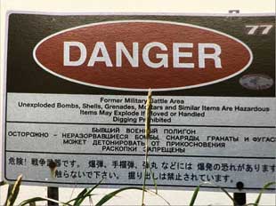
Warning sign at Kiska.
Image courtesy of the author.
Kiska D-Day, 15 August, was a typical Aleutian day. Dense fog covered the island, accompanied by high winds and a cold, heavy rain. Despite the weather conditions, almost 35,000 US and Canadian soldiers poured ashore. One Allied leader predicted that recapturing Kiska would be “bitter fighting with a Japanese force of from six to ten thousand” and that their goal was “to take as many prisoners as possible and … put a wedge into their Samurai code.”19
Heavy casualties were also expected based on American soldiers’ recent experience at Attu. For every 100 Japanese killed on Attu, seventy-one American soldiers were killed or injured. The estimated casualty rate expected for Allied soldiers at Kiska was 90 percent.20 Information gathered by the Alaska Defense Command and the Advanced Intelligence Center, North Pacific Area, showed that “the Japanese development of Kiska was much more extensive than the development of Attu. Almost all beaches possessed some defenses, including barbed wire and mines.”21
Allied commanders refuzed to believe that the Japanese could have completely evacuated Kiska.22 For days, American and Canadian troops searched the island that they thought was still under the control of Japanese forces. The only living creatures the American and Canadian soldiers found were a few stray Japanese dogs. “We dropped 100,000 propaganda leaflets on Kiska, one airman said, “but those dogs couldn’t read.”23
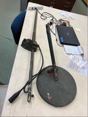
An American landmine detector used in the Aleutian Islands. Image courtesy of the author/Museum of the Aleutians.
Eventually more than 300 casualties would be recorded on Kiska. Some men were killed by friendly fire when confused and scared soldiers accidentally shot their comrades in fog-laden gunfights.24 Others were killed or injured by landmines and the timed bombs the Japanese left behind.25 Warnings were sent out not to pick up any Japanese candles as they were booby traps left behind.26 On 24 August 1943, The New York Times asserted, “2 KILLED AT KISKA; Land Mines and Booby Traps Encountered in Landing.”27
Deadly Legacy
While Attu is the only battle fought on American soil in World War II, its deadly legacy of conventional weapons contamination continues. In the three-week battle, more than 3,000 tons of ordnance were deployed. Currently, the most dangerous ordnance on Attu are the buster shells, which is a type of munition designed to penetrate Japanese targets buried deep underground, such as military bunkers. Live shells were found in the ammunition dump, and the island is off-limits to personnel without proper clearance.28
In 2013, the US Fish and Wildlife Service concluded that the threat of UXO and ERW from the fighting and occupation by both Japanese and Allied forces during World War II remains an issue on both Attu and Kiska. Despite the islands being designated as national wildlife refuges reserved for the conservation of wildlife and fish, UXO and ERW remain safety hazards. In particular, “[a]s the years progress, erosion exposes new sites while others are overgrown by vegetation.”29
As of 2016, “there are fears of unexploded munitions that haven’t either been discovered and removed, or otherwise disabled that perhaps in part drives these cautionary measures.”30 Few individuals visit Attu because the National Park Service has placed the island under restrictions.31 Previous US government-funded UXO and ERW investigations for Attu have found a 100-pound Army practice bombs; smoke pots; smoke generators; smoke grenades; flares; fuzes; barrage rockets; 250- and 500-pound projectiles; incendiary bombs and bomblets; 6-, 10-, 12-, and 14-inch projectiles; small arms ammunition up to .50-caliber; high-explosive anti-tank and high-explosive incendiary rounds; fragmentation bombs; 20-mm (high-explosive) and 40-mm warheads; and anti-personnel mines. An Army Corps of Engineers report concluded that “[o]rdnance and explosive waste was estimated in tons, with some concentrated and with significant amounts scattered throughout the island hidden by the dense vegetation.”32 At last count, twenty-five warning signs were posted around known UXO and ERW areas on Attu.33
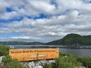
WWII National Historic area, Dutch Harbor, Aleutian Islands, Alaska. During WWII, this isolated mountaintop (US Army Fort Schwatka, Mt. Ballyhoo) fortification was home to 1,000 US servicemen. Their duty was to protect Dutch Harbor from Japanese seaborne attacks. Image courtesy of the author.
Kiska is now recognized as a National Historic Landmark and is part of the World War II Valor in the Pacific National Monument. Kiska is the only battlefield in the United States, and is only one of three battlefields worldwide, where there was no substantial human presence before the battle and where no subsequent alterations to the landscape have occurred.34
During the fourteen-month Aleutian Islands campaign to recapture Kiska, 3,000 tons of bombs rained down on the island, while the Japanese defenders mined and booby trapped their positions.35 Because of the intensive bombing efforts and the large quantities of abandoned ordnance left behind by the Japanese, large quantities of UXO and ERW remain on Kiska,36 where the traces of the battle are preserved in place and unchanged.
Because the full extent of UXO and ERW contamination is unknown and not all areas of Attu and Kiska have been investigated, the potential exists for such contamination to be present anywhere on these islands. Posted signs read “Warning! Kiska is a World War II battlefield. Unexploded ammunition is scattered throughout the landscape!”37
The author would like to thank JMU’s College of Arts and Letters for research support and Karen Macke, Collections Manager, Museum of the Aleutians, for archival expertise in assisting with this project. Additionally, the author would like to thank Michael Ashley of Cold Bay Lodge for guiding services to abandoned American defensive World War II positions in Cold Bay and along the Bering Sea coast.
 Ken Rutherford, PhD
Professor of Political Science
James Madison University
Ken Rutherford, PhD, is Professor of Political Science at James Madison University. He holds a PhD in Government from Georgetown University, and BA and MBA degrees from the University of Colorado, where he was inducted into its Hall for Distinguished alumni. For ten years he served as Director of JMU’s Center for International Stabilization and Recovery. He was a Peace Corps Volunteer in Mauritania (1987–1989), an UNHCR Emergency Refugee Coordinator in Senegal (1989), a humanitarian emergency relief officer in northern Kenya and Somalia (1993), and a Fulbright Scholar in Jordan (2005). Dr. Rutherford has published five books, including most recently, America's Buried History: Landmines in the Civi War. Rutherford teaches International Law.