
Explosive Weapons Use and the Environmental Consequences: Mapping Environmental Incidents in Ukraine
By Linsey Cottrell, Eoghan Darbyshire, PhD [ Conflict and Environment Observatory ], and Kristin Holme Obrestad [ Norwegian People’s Aid ]
CISR Journal
This article is brought to you by the Center for International Stabilization and Recovery (CISR) from issue 26.1 & 2 of The Journal of Conventional Weapons Destruction available on the JMU Scholarly Commons and Issuu.com
All conflicts result in environmental impacts. The use of explosive weapons can cause massive damage to civilian and industrial infrastructure, resulting in the contamination of air, soil, and water resources. The war in Ukraine has highlighted the heavy toll on the environment, and the risk of significant environmental harm.
Ukraine has an extensive and diverse industrialized economy, including heavy manufacturing and nuclear facilities. As well as the environmental risks from existing contamination linked to its industrial heritage, the targeting and damage to commercial, industrial, and energy infrastructure has exacerbated these risks for civilians and the wider environment. This means an increased risk of exposure for people living within or near impacted areas, as well as for humanitarian and mine action workers delivering support to these communities.
Data is critical and it is important that environmental incidents and their significance are mapped and monitored.1 This will help provide an indication of the geographical spread of environmental damage, and prioritize remediation needs. It is also important to communicate more widely the environmental consequences of conflict, which are often ignored or considered a low priority. This is despite the risk of environmental degradation undermining human health, livelihoods, and security, and despite the UN General Assembly declaring that everyone has the right to a healthy environment.2
Monitoring Conflict Pollution
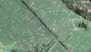
High resolution satellite image showing crater damage to agricultural land in June 2022, Dovhenke, Kharviv Oblast. Image courtesy of Maxmar Technologies/Twitter.
Conflict pollution describes the contamination caused by the direct damage to infrastructure, by the use of particular weapons, or from the absence or collapse of environmental governance during and after conflict.3
In conflict settings, collecting environmental data and monitoring the impacts of conflict pollution can be limited and extremely challenging. Satellite remote sensing can be used to fill the gap and a useful tool to monitor both short-term impacts and long-term environmental change.4 But remote sensing has limitations; for example, the majority of satellite sensors rely on the sun’s rays, and so cannot provide data when it is dark or cloudy. While radar imaging can overcome these challenges, it only orbits above many locations a few times each month, and so is of limited use for time-sensitive research. To fully understand the environmental risks, satellite data needs to be blended with more detailed information from the ground.
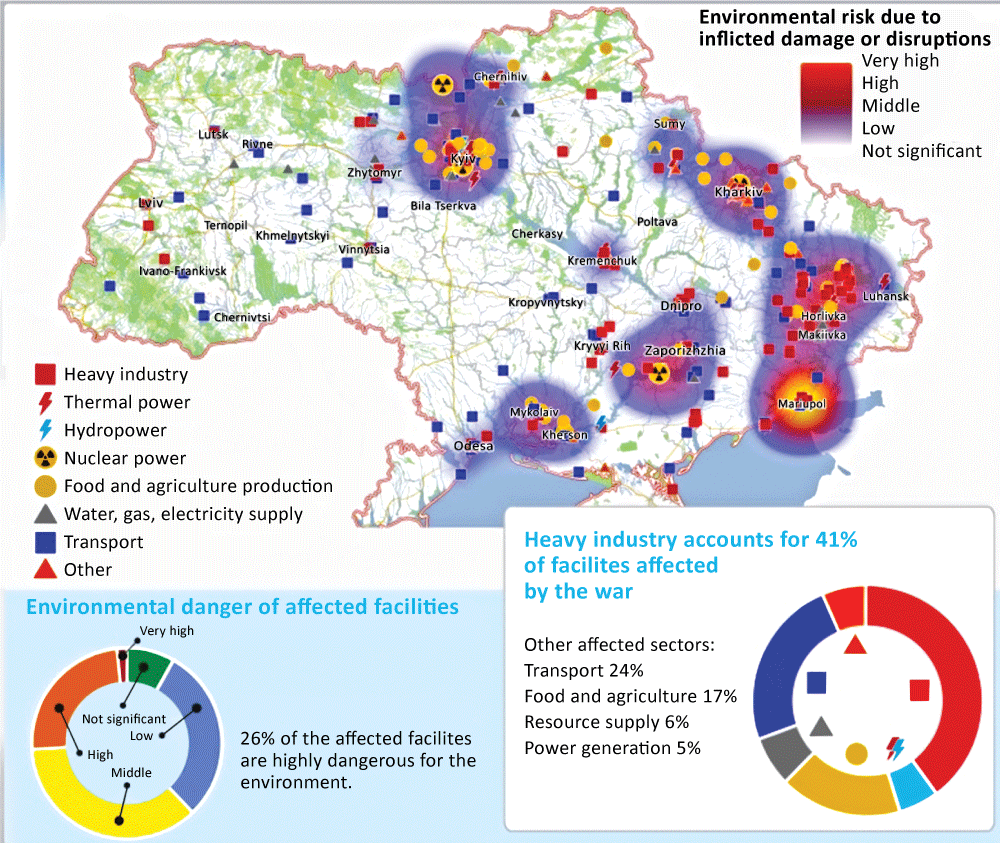
Figure 1. Mapping of environmental risks from damage to industry and infrastructure, based on data from https://ecodozor.org/. Image courtesy of Zoï Environment Network.
A range of data sources are required to generate robust remote assessments, which may include help to identify priority locations for remediation. The scale of environmental data collection in Ukraine is far beyond that of past and contemporary conflicts. International nongovernmental organizations (NGOs), including the Conflict and Environment Observatory (CEOBS), Zoï Environment Network, IMPACT, and PAX, have been collating data on environmental incidents to support agencies, and help inform the authorities and other humanitarian actors on follow-up sampling, evaluation, and remediation needs. Zoï Environment Network has used information primarily from government and traditional media sources to produce maps on its Ecodozor platform (see Figure 1).
The CEOBS database incorporates detail to enable an assessment of the environmental risk. The first step is to identify incidents. This is achieved via a semi-automated search of social media, in particular Twitter and Telegram, plus traditional media reports, tip-offs, or the use of pre-existing databases and monitoring networks. The next step is to collect and archive as much information on the incident as possible. This requires both the aforementioned sources and satellite data, such as before and after imagery5 or active fire data.6 By collecting and combining all this information, it is possible to locate precisely where an incident occurred, verify that it occurred and at the stated time, classify the incident type and severity of damage, and finally, assess the environmental risk. Verification is important given the potential for fake news, disinformation, or politicization.7 The environmental risk is established via a simple qualitative score-card which takes into account air, water, and soil pollution, and proximity to dense populations or ecologically important areas.
Nature of Environmental Incidents
The war in heavily industrialized Ukraine has seen attacks on a wide range of industrial facilities and infrastructure. There are thousands of entries in the Ecodozor database, and this only includes those incidents for which there is reporting. The true number is likely much higher.
Figures 2, 3, and 4 illustrate examples from the CEOBS database that indicate the broad range of incidents taking place in Ukraine, which can give rise to short- or long-term environmental concerns. Many incidents will have direct consequences on humanitarian mine action operations, which must be addressed under the standard operating procedures and risk assessments of organizations deploying humanitarian and mine action staff.
Within urban settings, there are multiple potential sources of pollution and proportionately more people vulnerable to the risk of exposure to contaminants. With commercial and industrial units, utility infrastructure, filling stations, workshops, fuel storage, and garages all located in urban areas, the use of explosive weapons can result in contamination and the release of a host of toxic and hazardous chemicals from damaged buildings and infrastructure. This can create airborne contaminants and can contaminate water resources and/or underlying soils, negatively impacting human health through direct contact, inhalation, or ingestion of chemicals or contaminated soils. It can also create indirect pathways to exposure, for instance from leaching through soils, migrating to underlying groundwater, and flowing into streams or rivers.
Although not unique to the conflict in Ukraine, the anticipated widespread presence of asbestos within building fabric and conflict debris also presents a serious health and environmental hazard. Ukraine was a major producer of asbestos, with high rates of asbestos use in construction over many decades. Records on the location, nature, and distribution of asbestos-containing materials in Ukraine, however are unclear, meaning that response plans must take into consideration the likely presence of asbestos and take action to reduce the risk of exposure and harm. 8
Other contaminants of potential concern include metals like lead and chromium, fuel oils, PCBs,9 fire retardants, and explosives. Their presence will vary depending on location, urban setting, age, nature of construction materials, and the type of land uses. Some contaminants will disperse and eventually degrade in the environment, but many do not and will persist for years.
There are also the risks associated with the use of specific weaponry. It is currently unclear if, or to what extent, depleted uranium (DU) ammunition has been used in the fighting in Ukraine.10 DU is both radioactive and chemically toxic. If the use of DU is confirmed, key potential exposure routes for people include contact, and the inhalation or ingestion of DU-contaminated soil or particulates.11
|
Facility #1: Agricultural warehouse, Dolgenkoe farm Incident description: Fertilizer explosion (ammonium nitrate) Impact: Significant physical damage and chemical release (including nitrogen oxides to air). No surface water in close proximity, but visible impact on soils. Preliminary risk screening: Medium (overall)
Figure 2. Dovhenke, Kharkiv Oblast, May 2022. Image courtesy of Pavlo Kyrylenko/Telegram. |
 |
|
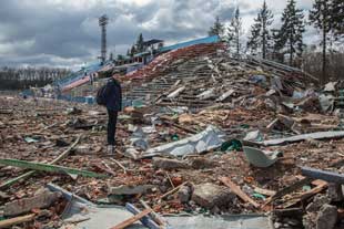
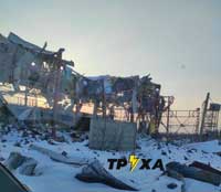
Facility #2: Waste management facility Incident description: Facility destroyed Impact: Significant physical damage, but no obvious fire or release of chemicals. Nearby surface water feature and visible impact on soils. Preliminary risk screening: Medium (overall)
Figure 3. Lyubotyn, Kharkiv Oblast, March 2022. Image courtesy of Tpyxa News/Twitter. |
 |
|
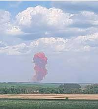
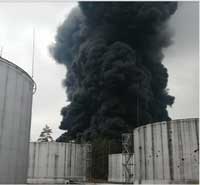
Facility #3: Aistra petroleum storage and reserve Incident description: Fuel fire Impact: Significant physical damage, fire and chemical release. No obvious nearby surface water, but visible impact on soils. At least six fuel silos destroyed. Preliminary risk screening: High (overall)
Figure 4. Chernihiv, Chernihiv Oblast, March 2022. Image courtesy of State Emergency Service of Ukraine/Facebook. |
 |
Support Through Collaboration
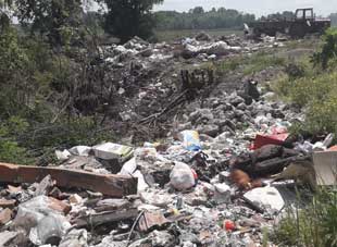
Observations during survey and clearance operations by mine action operators on waste, debris, and other pollution can support remediation planning. Image courtesy of CEOBS.
Impact monitoring is required to understand the on-going environmental risks and damage caused by conflict, yet challenging to conduct on the ground. Remote assessment databases are important, but these will not be comprehensive and incidents will be missed, particularly smaller incidents or those occurring in less populated areas.
As well as organizations collating data using remote tools, local actors are needed. Given technical and capacity constraints, collaboration and the provision of elementary environmental data and incident reporting by mine action operators and other civil society actors can be a useful, additional resource. Mine action operators could be an important part of such efforts in Ukraine, helping to report on-the-ground evidence or suspicion of pollution, or environmental damage (see Figure 5). Mine action operators are particularly well-suited to support this given their expertise in data management systems, evaluating risk, understanding risk priorities, and communicating these risks to local communities.
Supported by guidelines, such as a planned update to IMAS 07.13,12 mine action operators could report and provide eyewitness accounts of conflict pollution incidents. At a minimum, actions should be in place to manage risks including:
- Non-technical surveys to consider the potential for chemical pollution to be present in or adjacent to task areas, with specific questions directed to the local community and local authority;
- Health and safety files for task areas to include the potential for chemical pollution and control measures to be in place;
- Site reconnaissance to include a visual inspection of ground conditions, including checks for the signs of environmental incidents and risk of environmental harm;
- Provision of appropriate personnel protection equipment for field staff;
- Site induction to inform all site staff of anticipated ground conditions and operating procedures;
- Maintenance of appropriate records, detailing the date, location, nature, cause, and extent of the environmental incident and reporting action taken; and
- Reporting of incidents to landowners or users, and, where possible, the local authorities or other agencies involved in post-conflict and field assessments.
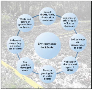
Figure 5. Examples of evidence of environmental incidents or damage. Image courtesy of CEOBS.
Mine action operators are not environmental specialists, and collaboration with environmental partners should be encouraged, both to allow delivery of competency training, where needed, and to disseminate data on conflict pollution. Environmental NGOs in Ukraine, such as Ecoaction and Environment People Law,13 have been investigating and assessing the environmental impacts of the conflict and the wider environmental effects. There is also wide support across civil society organizations in Ukraine for a green recovery policy, acknowledging that the repeal or weakening of any environmental legislation in post-conflict recovery would be unacceptable.14 Additional measures may be required, when pollution-impacted areas are identified or suspected. Under such circumstances, operating in these areas may require specialist environmental support or advice, including the development of task-area specific operating procedures (for example for the control of excavated materials, waste, dust, and drainage) and enhanced local engagement.
To fully support the resolution of the UN Environment Assembly addressing conflict pollution,15 data will be needed to inform the environmental assessments, target remedial action for higher risk sites, and enable reconstruction. Pollution can inflict physical, psychological, socioeconomic, and cultural harm on individuals and communities, and an inadequacy of data is one of the barriers to assisting victims either in Ukraine or elsewhere.
The remote environmental incident monitoring in Ukraine undertaken by CEOBS to date has been supported by the CEOBS and Norwegian People’s Aid partnership agreement with the Norwegian Ministry of Foreign Affairs and by the United Nations Environment Programme.
 Linsey Cottrell
Environmental Policy Officer
Conflict and Environment Observatory
Linsey Cottrell is the Environmental Policy Officer at the UK-based charity the Conflict and Environment Observatory (CEOBS). Cottrell is a Chartered Environmentalist and registered in the UK as a Specialist in Land Condition. She was also a trustee for the Institution of Environmental Sciences from 2016 to 2022. Before joining CEOBS in 2019, she worked in the environmental consultancy sector on contaminated land and environmental risk assessment.
 Eoghan Darbyshire, PhD
Researcher
Conflict and Environment Observatory
Eoghan Darbyshire, PhD is a Researcher at the CEOBS, specializing in the use of remote sensing techniques to monitor the environmental impacts of conflicts. Darbyshire has a PhD from the University of Manchester, and worked as a post-doctoral researcher developing instrumentation and conducting field campaigns measuring urban pollution. He also has a degree in Environmental Science and a MRes in Physics of the Earth and Atmosphere.
 Kristin Holme Obrestad
Senior Climate and Environmental Advisor
Norwegian People’s Aid
Kristin Holme Obrestad is the Senior Climate and Environmental Advisor at Norwegian People’s Aid (NPA), responsible for developing NPA’s approach to climate, environment, and conflict on a policy and operational level, and greening the organization. Holme Obrestad has a Master’s in Political Science and has an extensive background from policy, mine action, and environment work.