
Open-Source Research and Mapping of Explosive Ordnance Contamination in Ukraine
By Andro Mathewson [ The HALO Trust ]
CISR Journal
This article is brought to you by the Center for International Stabilization and Recovery (CISR) from issue 26.1 & 2 of The Journal of Conventional Weapons Destruction available on the JMU Scholarly Commons and Issuu.com
Due to Russia’s full-scale invasion of Ukraine, the scale of explosive ordnance (EO) contamination in Ukraine has reached unprecedented levels, necessitating new methods to assess and track the different types of ordnance and the level of contamination across the country. As the most documented, active war on social media to date, The HALO Trust (HALO) has successfully harnessed open-source research to better plan and conduct survey, clearance operations, and explosive ordnance risk education (EORE) across the country.
Russian’s full-scale invasion of Ukraine, which began in February 2022, has become “the first open-source war,” where almost every aspect of the conflict on the ground has an online counterpart—from logistics and guidance systems to humanitarian aid delivery and conflict mapping.1 As the transport of supplies occurs on the ground, the plans thereof are drafted online. As the soldiers adjust the guidance systems of their weaponry on the frontlines, engineers online are solving issues that arise. As humanitarian aid is being delivered across Ukraine, teams of analysts are crunching data to prioritize the regions with the highest need. As the conflict progresses and frontlines move, researchers are mapping the conflict and its devastating effects on Ukraine, including the EO that is left behind in areas where the fighting has subsided.
The scale of EO contamination in Ukraine has reached unprecedented levels, necessitating new methods to assess and track the different types of EO and the level of EO contamination across Europe’s largest country due to its inaccessibility to organizations working in-country as a result of the ongoing conflict. Harnessing open-source research, satellite imagery, and online investigations, HALO is leading this effort and has been able to assess and map EO contamination across Ukraine for humanitarian end-purposes, allowing HALO staff working in Ukraine to better plan and conduct survey and clearance operations as well as EORE across the country.
HALO has been working in Ukraine since the end of 2015 in the government-controlled areas of Donetsk and Luhansk oblasts. Over seven years, HALO teams conducted non-technical survey (NTS), clearance, and risk education throughout the region, particularly along the contact line that existed until February 2022. Russia’s full-scale invasion in February temporarily brought survey and clearance work to a halt, while staff focused on moving their families to safety in the west of the country and assisted with aid distribution, risk education, and first aid training. The Russian withdrawal from Kyiv, Chernihiv, and Sumy oblasts by early April 2022 provided a window for operations to resume safely and HALO relocated its operations to a base just outside Kyiv to be able to work in these three regions. Despite the uncertainty during the initial stages of the war before the partial Russian withdrawal, HALO wanted to be fully prepared for future operations and began using a “remote” approach to understand the type of EO used and the scale and impact of contamination within Ukraine. This article explains the path HALO has taken to track EO and explosive remnants of war (ERW) across Ukraine online using open-source research and mapping techniques. Such well-
structured open-source research based on social media is becoming an increasingly important part of the desk assessment phase and contextual information required for NTS.2
The Context in Ukraine
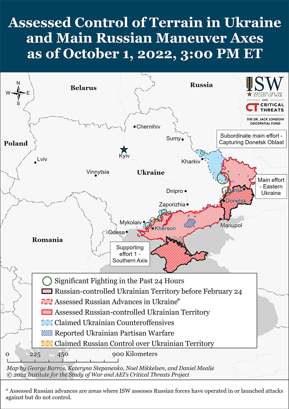
Figure 1. Assessed control of terrain in Ukraine as of 20 July 2022, 3:00 p.m. ET. © 2022. Institute for the Study of War (ISW) and American Enterprise Institute’s Critical Threats Project made possible by the Dr. Jack London Geospatial Fund at ISW. Figure courtesy of ISW.
By mid-July, Russia occupied approximately 126,610 square kilometers of Ukrainian territory,3 almost twenty-one percent of the entire country, including areas in the east, south, and the Crimean Peninsula. Since the full-scale invasion started on 24 February 2022, the conflict has seen more than an estimated 100,000 deaths of soldiers on both sides, foreign volunteers, and civilians.4 During the initial stages of the war in February and March 2022, Russian troops moved swiftly across northern, eastern, and southern Ukraine, encircling cities such as Kharkiv, Kyiv, and Mariupol. By April, Russian forces had retreated or been pushed back from most newly occupied areas, except along Ukraine’s southern coast reaching Kherson in the west and large parts of Luhansk, Donetsk, Kharkiv, and Zaporizhia Oblasts, creating a frontline of approximately 2,000 kilometers long.
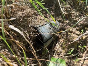
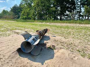
9N255 cluster submunition in Ukraine, June 2022. Image courtesy of The HALO Trust.
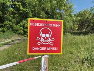
As with all conflicts that involve conventional military technologies and tactics, such as the use of heavy artillery and anti-personnel and anti-tank landmines for area denial, the war in Ukraine has led to vast amounts of EO contamination across the country, leaving civilians directly at risk. However, the situation is worsened by the indiscriminate use of cluster munitions and the presence of kicked-out munitions from destroyed military vehicles and ammunition depots, which also pose a threat to civilian bystanders. Understanding these different threats to civilians and the location of EO contamination is critical to effective and efficient humanitarian demining operations.
Defining Open-Source Research
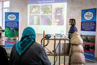
Risk education, Ukraine, 2022. Image courtesy of The HALO Trust.
Open-source research is the process of collecting and analyzing legally gathered information from publicly available sources only, without the use of clandestine collection techniques and containing no information from private or classified sources. Open-source research can be conducted in a variety of ways depending on the scenario, information desired, and availability. In simple terms, it revolves around the collection of information, predominantly online but also via verbal or written communication, with the end goal of analyzing the collected data to extrapolate an analysis. Depending on the situation, the analysis can be used to inform the public about an important topic, advise public and national policies, or inspire a call to action.
While open-source research is frequently used in national security and law enforcement, with the expansion of the internet, smartphones, and social media, it has become an accessible tool used by non-governmental organizations and individuals alike.5 Since the start of the Syrian civil war in 2011 and the conflict in eastern Ukraine in 2014, open-source research has also become a constant of modern warfare, helping to thin out the fog of war.6 Many global organizations use open-source information, including the United Nations, to support peacekeeping operations and plan the delivery of aid during times of crisis or disaster. The war in Ukraine is by far the most active conflict on social media of all time, consequently allowing HALO to leverage the high volume of information using open-source research for the collection and analysis of data on EO contamination in Ukraine. This in turn has enabled HALO to better plan and conduct operations and carry out EORE activities more efficiently and effectively. This includes determining the priorities for the deployment of NTS and clearance teams, to informing the procurement of the most appropriate equipment for the expected threat.
HALO’s Approach to Open-Source Research
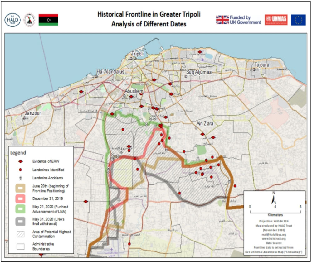
HALO has previously used open-source research for a small-scale project in Tripoli, Libya, where researchers focused on social media posts that were sharing photos and videos, indicating evidence of landmines and improved explosive devices. The exact locations of contamination finds were then placed on a map alongside the frontlines of the 2018 battle for Tripoli (see Figure 2). Plotting the locations of unexploded ordnance and battlefield frontlines enabled HALO to prepare for NTS—the process of identifying and marking suspected and confirmed hazardous areas—and prioritize areas with high levels of contamination and high levels of human activity. Since March 2022, this approach has been successfully applied to and expanded in the Ukraine context.
HALO’s current open-source research methodology includes five central stages, as outlined in Table 1.
| No. | Research Stage | Ukraine Context |
| 1. |
Determining end goals |
Map the EO contamination in Ukraine due to the Russian invasion, including the location of civilian accidents due to ERW (see objectives in Table 2) |
| 2. |
Identify sources |
Social media (Telegram, Twitter, and Facebook), traditional media (Ukrainian and international news outlets), think tank reports, and research organizations (Live Universal Awareness Map and Armed Conflict Location Event Database (ACLED)) |
| 3. |
Conduct searches online |
Conduct deep-dive searches through online media for relevant events within set objectives (see Table 2) |
| 4. |
Verify/geolocate events |
Use verification and geolocation techniques to ascertain the veracity of reports and identify the precise location of events |
| 5. |
Mapping, collation, and |
Extrapolate information from the data to inform HALO’s survey, planning, clearance operations, and EORE delivery |
|
Table 1. HALO’s open-source research methodology. |
||
|
Objectives/Categories |
Purpose |
|
Track the movement of frontlines |
To locate areas with a high likelihood of EO contamination |
|
Track areas of prolonged fighting |
Provides evidence points for future NTS teams to investigate |
|
Identify locations of cluster munition strikes |
Provides evidence points for future NTS teams to investigate |
|
Identify locations of any EO |
Provides evidence points for future NTS teams to investigate |
|
Identify locations of destroyed military vehicles |
Provides evidence points for future NTS teams to investigate |
|
Identify locations of air and missile strikes |
Provides evidence points for future NTS teams to investigate |
|
Identify all types of EO used in the conflict |
Tailor EORE campaign and materials for items found in the region; Tailor explosive ordnance disposal (EOD) training ID guides; identify suitable procedures and EOD tools; inform all HMA actors of what to expect in the region; inform procurement of machines and detectors |
|
Identify areas of landmine/improvised exposive device contamination |
Provides evidence point for future NTS teams to investigate; information can be shared with other humanitarian actors enabling safer delivery of humanitarian aid |
|
Identify any strikes on ammunition storage facilities |
Provides evidence points for future NTS teams to investigate |
|
Identify vehicles and weapon systems used in the conflict |
Assists in defining what type of munitions could be used by these platforms, which then helps with EO recognition |
|
Identify the location of civilian |
Monitor the number of civilian casualties due to UXO; report this figure to other humanitarian actors; assist in planning or provision of victim assistance activities |
|
Identify destroyed infrastructure |
Critical information for wider humanitarian effort |
|
Understand the causes of non-HMA |
Provides evidence point for future NTS teams to investigate; assists in defining potential hazards to deminers in HMA. |
|
Table 2. Identified objectives. |
|
The first of these stages, determining the end goals and the focus of research, resulted in the identification of thirteen objectives with different purposes as outlined in Table 2.
The second step involves identifying publicly available sources to procure information. The majority of HALO’s information stems from social media platforms, primarily Twitter, Telegram, and Facebook, but also Reddit and YouTube. HALO uses advanced search techniques such as boolean logic searches to filter content and find images and videos about the aforementioned categories. Another large source of information is local Ukrainian news and media outlets, such as Suspline Media, Unian, and RBC-Ukraine, as well as official press releases of Ukrainian local police forces or government officials. Finally, HALO also utilizes publicly available pre-collated databases with pertinent information, such as those by Live Universal Awareness Map, ACLED, the Center for Information Resilience, and volunteer groups, such as Geoconfirmed.
The third step of HALO’s open-source research project is verifying the data that is discovered using the different sources previously mentioned. HALO follows a four-step verification process. This begins with assessing the originality of the image or video in question. If the image or the video was used before, it is frequently possible to trace it back to the original online posting via a reverse image and/or video search. There are a multitude of different tools online that allow such searches and will show if an image has been posted before the current post. This helps to minimize false claims of EO items apparently found in Ukraine, which might actually stem from other conflicts. After determining the originality of the content, the reliability of the source is assessed on a scale of low, medium, or high reliability. If the information stems from official Ukrainian government sources, a well-recognized media outlet, or social media account and can be corroborated by at least one other source, it is classified as “highly reliable.” If it cannot be corroborated by other sources, it falls under the “medium reliability” category. The previous two categories are added to HALO’s database and map, which is shared with other actors in the humanitarian mine action (HMA) sector. If it stems from a previously unknown source and provides little detail, it is classified under the “low reliability” category and not included in our public-facing datasets until it can be verified. The third step in the verification process is geolocating the image. Geolocation is the identification of the geographic location of an object in an image via a variety of data collection mechanisms, such as satellite imagery and GPS metadata. However, HALO only uses satellite imagery and other mapping tools to geolocate source material, as metadata is often sensitive and has restricted access. The geolocation of an image not only helps to ascertain the veracity of the content (e.g., does it depict an event within Ukraine or is it from another conflict), but it also facilitates HALO to create a detailed map depicting all events discovered by open-source research, creating a portrait of the conflict in Ukraine, as shown in Figure 3.7
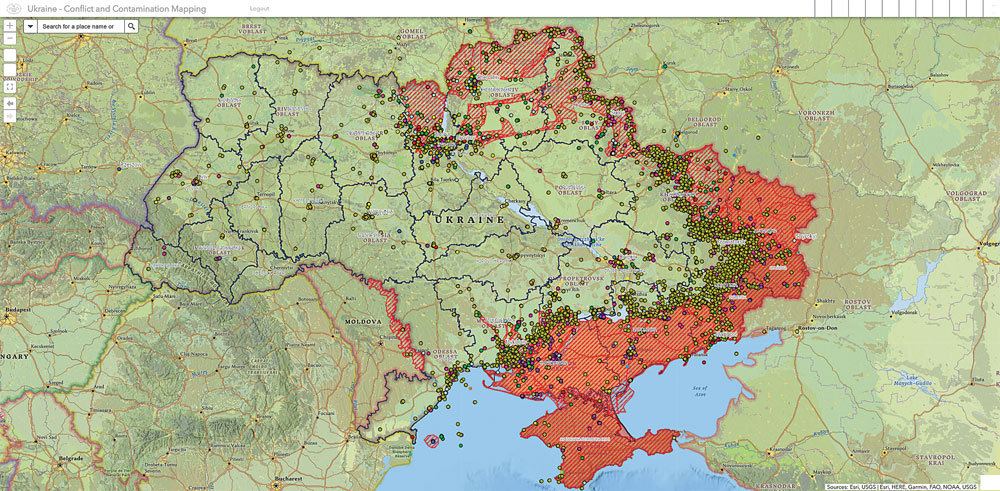
Figure 3. HALO’s conflict and contamination map as of 26 September 2022. Each dot corresponds to a unique event involving EO and the colors represent a different category based on HALO’s project objectives.
This enables HALO to plot areas with high EO contamination (according to the previously mentioned objectives) and overlaps them with areas of high human activity, such as densely populated areas or farmland. This subsequently allows HALO to prioritize different survey, clearance, and EORE tasks. The final step of the verification process is assessing when the image or video was posted online. If it was posted before the annexation of Crimea and the occupation of the eastern reaches of Luhansk and Donetsk Oblast in 2014, the content definitively does not portray (new) EO in Ukraine.8 If an image is posted post–2014, it increases the likelihood that it accurately depicts ERW in Ukraine.
The last stage of the open-source research process is to collate and analyze the data, which allows for the production of several different outputs, all of which help to inform either HALO’s operations or HALO’s donors and other humanitarian organizations. At the time of publication, HALO has gathered and verified 20,000 unique events, within the thirteen categories previously mentioned, showing the location of each event, including 196 accidents involving civilians (112 deceased and 257 injured).9 These are depicted in Figure 4.
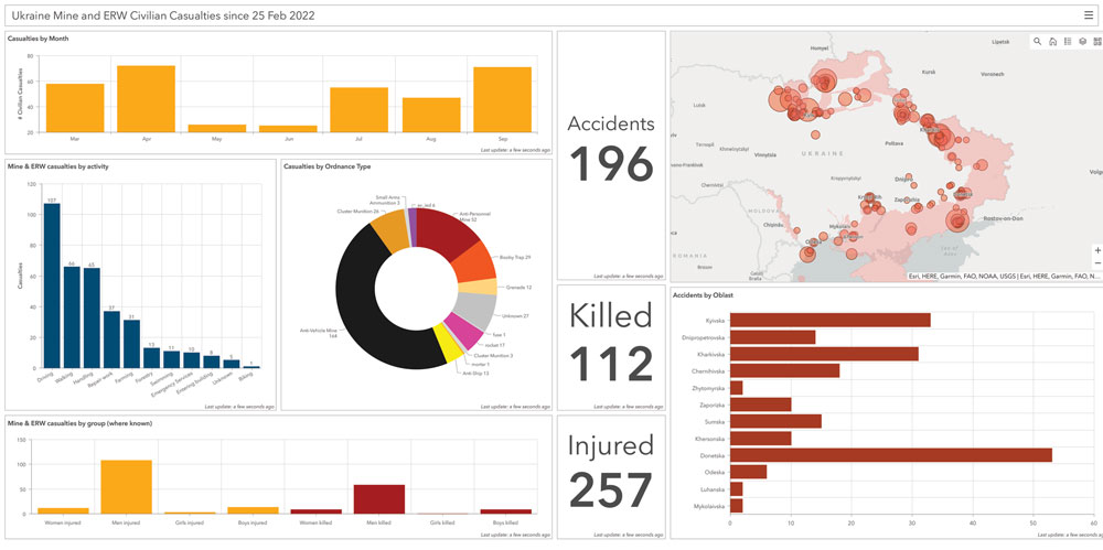
Figure 4. HALO’s dashboard showing data gathered on civilian accidents due to UXO in Ukraine. Figure courtesy of HALO.
HALO’s research has also identified 400 unique types of EO used in the conflict, primarily Russian or Soviet-made munitions but also many Western designs. HALO does not currently track different types of small arms and light weapons (SA/LW). However, the tracking of SA/LW represents a potential area of expansion for the project, especially to focus on Man Portable Air Defense Systems (MANPADS), which have been used extensively throughout the war. The knowledge accumulated through open-source research has allowed HALO to understand the EO contamination of Ukraine in-depth and has aided in the planning of areas of operations, prioritization of tasks, training of staff, equipment purchases, and risk education activities.
An example of HALO’s open-source research leading to clearance operations is one of HALO’s tasks in the region east of Kyiv, near the village of Hoholiv. On 5 April 2022, a tractor hit an anti-vehicle mine, resulting in the injury of the driver. This was reported in the local newspaper, the Brovary Tribune.10 The site of this accident subsequently became one of HALO’s first clearance tasks after the Russian withdrawal from Kyiv Oblast earlier that month, which allowed HALO to safely resume operations in the region.
While incredibly valuable to HALO, open-source research does come with its own set of unique challenges. One of the major challenges is the impossibility to collect all information on EO contamination across Ukraine. While the level of detail in reporting of the conflict is immense (to the level that it creates the issue of informational overload), there will be explosive events that remain unreported due to the fog of war and the immensity of the scale of Ukraine and the war itself. Additionally, the complete verification and precise geolocation of data is sometimes impossible, either due to the presence of misinformation or the lack of sufficient information associated with the imagery or in the image itself. Another challenge is the size of resultant datasets, numbering in the tens of thousands, which require cleaning while each data point requires verification.
A final challenge faced by HALO in conducting open-source research is the policies of many social media companies that remove content due to its graphic nature before HALO can access and archive it for verification and geolocation. Despite these issues, however, HALO’s open-source research and mapping project has shown promise in helping to understand the progression of the conflict and its resultant effects on Ukraine.
Limitations of Open-Source Data
300m 9M55 rocket, Ukraine, 2022.
Both social media and news media tend to emphasize the new and unusual. For example, there has been extensive coverage of the use of the POM-3 scatterable mine and improvised munitions such as drink cans with explosives dropped by altered commercial off-the-shelf drones. Yet, the frequency of news reports does not match their prevalence on the ground, nor their impact on civilians.
Casualty data from open-source reporting, followed by the work of HALO’s NTS and clearance teams, so far demonstrates that anti-vehicle mines—primarily the TM-62M variant—are causing the majority of accidents with the highest number of casualties. Clearing the land of anti-vehicle mines is subsequently where the bulk of HMA resources will need to be committed.
Moving Forward and Wider Use
Moving forward, HALO is looking to expand the scope of tools used in this project to reduce the amount of manual labor needed for the data processing aspects of the research. This potentially includes leveraging artificial intelligence to assist with both internet scraping and data cleaning tasks although these tools must be designed to work with original source data in Ukrainian and Russian to minimize the chance that any details are lost in translation.
As time progresses, HALO will begin to evaluate the effectiveness of the project, with a special focus on understanding its use for targeted EORE activities and assessing what proportion of recorded events have resulted in the subsequent creation of suspected hazardous areas or confirmed hazardous areas once followed up by NTS teams on the ground. Importantly, the use of such open-source research techniques is easily transferable to other locations and projects within the HMA sector and beyond, especially where in-country access is restricted for whatever reason or there is a lack of data regarding EO used in the conflict and the resultant contamination. The ability to conduct in-depth research online allows organizations like HALO to have a detailed understanding of the conflict even before stepping on the ground.
 Andro Mathewson
Research Officer
The HALO Trust
Andro Mathewson is a Research Officer at The HALO Trust, leading HALO’s open-source research project of the conflict in Ukraine. He also serves as a Capability Support Officer working to develop to programs and R&D initiatives. Matthewson received his Master’s degree in International Relations from the University of Edinburgh and Bachelor of Arts in Politics, Philosophy, and Economics from the University of Pennsylvania. You can reach him via Twitter at @andro_mathewson.