
Climate Change and Extreme Weather:
How Can Mine Action Programs Adapt to Our Changing Environment?
CISR
This article is brought to you by the Center for International Stabilization and Recovery (CISR) from issue 25.2 of The Journal of Conventional Weapons Destruction available on the JMU Scholarly Commons and Issuu.com.
By Linsey Cottrell [ Conflict and Environment Observatory ] and Carlie Stowe [ PeaceTrees Vietnam ]
Extreme weather events around the world are already impacting land that is contaminated with explosive ordnance (EO). Chronicling these events is not yet standardized, but these events will become more frequent as our climate changes. The uncertainty around climate change, related risks, and how these will regionally impact mine action operations makes it difficult to prioritize and plan for mitigation and adaptation measures. With limited guidance currently in place for the mine action sector, the introduction of climate change adaptation principles must be supported, and operational and risk management plans must be scrutinized to ensure that any additional climate change–related risks can be effectively managed. This would have the potential to reduce future impacts on operations, improve the efficacy of current work, and help build climate resilience for EO-affected communities.
Climate change refers to a long-term and large-scale shift in global weather patterns and average temperatures.1 The Paris Agreement on climate change is a legally binding international treaty aiming to keep the increase in global average temperatures to below 2 degrees Celsuis. Climate scientists agree that the global and regional effects of climate change due to human activity are already a reality.2 In August 2021, the report by the Intergovernmental Panel on Climate Change starkly warned of increasingly extreme heatwaves, droughts, and flooding, and that the role of human influence in the climate system is undisputed.3 Global temperatures have risen by an average 1.1 degrees Celsius since the nineteenth century and continue to rise.
The effects of climate change are wide-ranging. The effects vary depending on location, and can lead to more intense rainfall, increased risk of flooding and landslides, more frequent and intense dry spells, higher average temperatures, increased risk of wildfires, warming oceans, sea-level rise, and permafrost thawing. The impact of these events on humans is becoming evident, with more extreme weather linked to forced displacement, migration, and food insecurity, particularly in low-income countries.
Planning for adverse weather and environmental conditions already forms part of operational and risk management plans for mine action programs. The likelihood of more frequent, more intense, and less predictable extreme weather events due to climate change means that these plans must be scrutinized to ensure that any additional climate change-related risks can be effectively managed, so that operating capacity and the safety of field staff is not compromised.
The link between climate change and mine action operations may vary, as each region will be impacted in different ways. Climate change impact will also depend on any coping mechanisms already in place within programs. Many conflict-affected countries are located in areas considered among the most vulnerable to the effects of climate change, and are less prepared to adapt and less resilient to the impacts.
Climate adaptation refers to altering the way we live, work, or behave to reduce vulnerability to the inevitable impacts of climate change due to past and on-going greenhouse gas emissions. Land use and land management—key in mine clearance operations and the release of land following clearance—play an important role to mitigate and adapt to climate change. Soil erosion caused by the removal of vegetation, flooding, or the use of heavy machinery can reduce agricultural productivity and increase carbon losses from soil to the atmosphere. Soil is the largest terrestrial store of organic carbon.4 This means that as well as maintaining good environmental practices during mine clearance operations, there must be better planning of post-clearance land use as part of humanitarian mine action (HMA) programs. This will help ensure that land is used sustainably and support is given to communities to adopt appropriate climate adaptation and mitigation measures.
Affected Regions and Impacts
Extreme weather events around the world are already impacting land that is contaminated with EO. Chronicling these events is not yet standardized, but these events will become more frequent as our climate changes. The impact of severe flooding on mine action in Bosnia and Herzegovina, Croatia, and Serbia has already been well-documented.5 Climate change variables can influence EO survey and clearance activities across different regions, leading to increased risks to communities and the need to adapt operations.
Heavy deforestation across the Eastern Forest Complex of Afghanistan increases soil erosion and reduces soil productivity, which can be exacerbated by climate change. Image courtesy of Ayub Alavi.
Many EO-contaminated regions are also experiencing the combined effects of climate change and high rates of deforestation. Tree cover and forests provide multiple environmental and climate change mitigation benefits. For example, in the east of Afghanistan, between 50 and 80 percent of tree cover was lost between 1977 and 2002.6 In 2019, just 1.5 percent of Afghanistan was estimated as forest or woodland.7 The severity of flooding impacts in Afghanistan during 2020 has been attributed to the significant loss of tree cover.8 Heavy rainfall on bare or sparsely vegetated slopes can cause flash flooding since the ground has minimal capacity to retain water runoff.
Across Angola, the full impact of climate change on EO-contaminated areas is unclear, although there are documented reports of mines being washed up with floodwater.9 Seventeen out of the eighteen provinces across Angola are contaminated or suspected as contaminated with EO, with all provinces experiencing severe flooding in recent years. Climate change projections estimate increased rainfall variability and intensity for parts of Angola, which increase the likelihood of extreme flooding events. 10, 11
Flooding or landslides causing the movement of mines can also result in complex transboundary issues. In 2021, the Lebanon army reported that floodwaters had caused mines located along the Lebanese-Syrian border to migrate into Lebanese territory.12 This makes clearance problematic due to uncertainty around location, distribution, and condition. This is in addition to political and territorial responsibility for clearance activities. Tajikistan’s National Mine Action Strategy 2017-202013 also recognizes that “[a]s a result of natural disasters, it is possible that some minefields or individual mines have moved to the territory of the Republic of Tajikistan, although, at the moment, their exact location and area are not known.”
The increased risk of wildfires due to higher temperatures and longer dry seasons will mean additional risks to communities in EO-contaminated areas and will hamper mine action programs. In Ukraine, firefighting and evacuation measures were even more challenging during the 2020 wildfires due to the presence of landmines.14
Climate change also drives the movement and resettlement of people. As communities move, this may mean that areas prioritized for survey and clearance will need to be reassessed given the increased pressures on land use. Additionally, people may be exposed to different levels of risk as they move to new areas without historical knowledge of conflict and contamination. This could require a modified approach to EO risk education (EORE). Additionally, people with no historic knowledge of conflict and contamination moving into areas may also be exposed to different levels of risk, requiring a modified approach to EORE.
The selection and use of equipment for mine clearance operations will also be affected by climate change. Mine detection dogs (MDDs) for example are unable to work in wet conditions and some detection equipment (such as pulse induction detectors) has lower performance in high humidity.
Although rare, munitions stockpile explosions are also linked to hot weather. Munitions are designed to withstand intense heat in the short term, but prolonged high temperatures and humidity can destabilize them, weaken their structural integrity, damage seals, and increase the risk of explosion. In 2018, the unplanned explosion at a munition site in Baharka, Iraqi Kurdistan, took place during scorching summer temperatures, which is not a unique event during Iraq’s summer.15 Storm surges and warmer sea temperatures due to climate change may also significantly increase risks to people and marine life from the legacy of marine-dumped ordnance, and will require specific assessment and management. This includes the potential risks from hazardous chemicals leaching from corroded ordnance.16
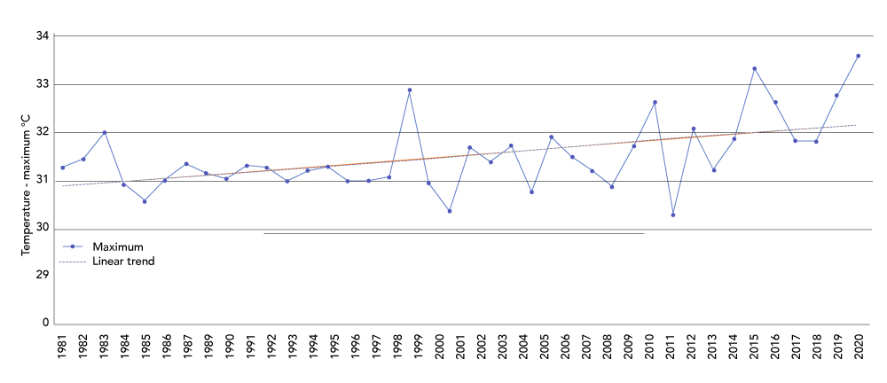
Figure 1. Graph shows an overall increase in annual maximum temperatures for Quảng Trị, 1981–2020. Figure courtesy of Earth Map and the ERA5 European Centre For Medium-Range Weather Forecasts (ECMWF).
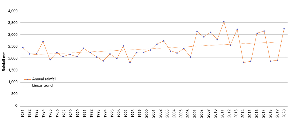
Figure 2. Graph shows an overall increase in annual rainfall for Quảng Trị, 1981–2020.
Figure courtesy of Earth Map and Climate Hazards Group.
Vietnam Case Study
Increased Risks Due to Climate Change
Vietnam faces high disaster risk levels driven by elevated exposure to flooding (riverine, flash, and coastal), tropical storms, and storm surges.17 The country is predicted to be one of the top five countries most impacted by climate change,18 presenting complex challenges to the population and the economic growth of the country. River flooding alone is estimated to impact on average 930,000 people per year in Vietnam and causes approximately US$2.6 billion in annual economic losses.19 It is estimated that by 2030, these numbers will increase to 1,363,000 people affected and US$6.2 billion in economic losses, respectively.20 With coastline stretching the length of the country, without proper mitigation and adaptation efforts, it is estimated that 12 million people will be permanently impacted by inundation.21
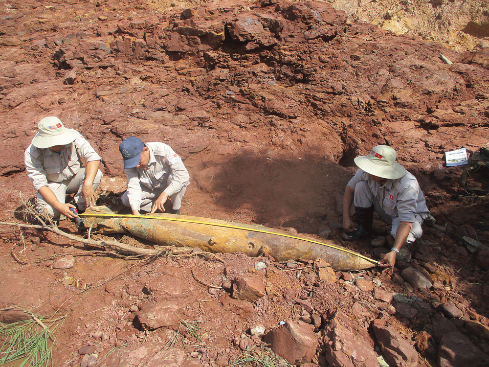
PeaceTrees Vietnam removing 500 lb MK82 air-dropped bombs in Huong Hoa District, Quảng Trị, which were exposed following the October 2020 storms. Images courtesy of PeaceTrees Vietnam.
The United States dropped 413,130 tons of submunitions over Vietnam between 1965 and 1973, reportedly striking 55 provinces and cities. Landmines along the border between China and Cambodia laid during conflicts in the 1970s also remain. An impact survey released by the government of Vietnam in 2018 estimated that 19 percent of Vietnam’s land surface remained affected by EO.22 Quảng Trị Province is considered one of the most heavily contaminated provinces in the country. Only around 28 percent of the currently established confirmed hazardous areas (CHA) in the province have been cleared.
Currently the Provincial Military Command’s explosive ordnance disposal (EOD) teams, Mines Advisory Group (MAG), Norwegian People’s Aid (NPA), and PeaceTrees Vietnam (PTVN) operate in the province. The Quảng Trị Mine Action Centre (QTMAC) is responsible for the coordination of mine action activities in the province, including task prioritization: MAG focuses primarily on clearance with an additional team for survey; NPA focuses on cluster munition remnants surveys (including non-technical [NTS] and technical survey [TS]), clearance, and capacity development; and PTVN undertakes clearance operations in the province.
Climate Trends and Recent Incidents
Open-source data for Quảng Trị Province on maximum annual temperatures and annual rainfall indicate overall increases over the last four decades (see Figures 1 and 2). Quảng Trị Province is mountainous and heavily reliant upon agriculture. The province is already experiencing the impacts of climate change through unpredictable precipitation patterns, higher maximum temperatures, and increasingly disastrous typhoon seasons. In October and November 2020, eleven provinces in central Vietnam, including Quảng Trị, were hit by a series of tropical monsoons, depressions, and other uncharacteristically adverse weather patterns directly impacting an estimated 1.5 million people, and causing an estimated US$1.3 billion of damage in the six worst hit provinces.23 These storms, reported to have been the worst in over a century, forced 15,372 households in Quảng Trị to evacuate.
Mine action operations in the province were also impacted, with both NPA and PTVN reporting having to pause field operations for up to four weeks, as well as having staff directly impacted by the flooding and landslides, further delaying their ability to return to work.
Phạm Hoàng Hà, country director of PTVN, reported that the storms continue to have a lasting impact on operations. In the immediate aftermath of the storm, PTVN was tasked with responding to ten large air-dropped bombs (including six MK82 500 lb and one MK83 1000 lb bombs), exposed as a result of the flooding and landslides. NPA was also tasked to respond to a MK82 500 lb bomb that was exposed by the flooding. In some cases, flooding and the washing away of topsoil can also have an operational impact on EO clearance. Kimberley McCosker, project manager for NPA Vietnam, explained that it can expose items otherwise well below the national clearance depth and therefore beyond what would routinely be searched. However, the risk of displaced EO contaminating additional areas of land remains, although there is no evidence that this has yet taken place in the province.
Plans for the Future
Both PTVN and NPA have begun to consider how mine action operators can tackle the challenges posed to operations by climate change. PTVN already works closely with communities to support their socioeconomic development needs and capacities after land clearance has been conducted. Recently, PTVN conducted land clearance for well projects in communities that are experiencing water shortages in the central highlands of Quảng Trị Province. NPA has dedicated an Environmental Protection Officer for their program in Vietnam and will be collecting environmental data as part of their community liaison (CL) and NTS process. Additionally, NPA is exploring how environmental and climate change education can be incorporated into their EORE programs.
Mine Action Standards, Strategies, and Guidance
International Mine Action Standards (IMAS) are intended to guide development of national mine action standards (NMAS) and standard operating procedures. Although they partially incorporate the need to consider weather and risks from other natural hazards,24 there is currently no specific reference to the increased risks due to climate change and how this should be addressed.
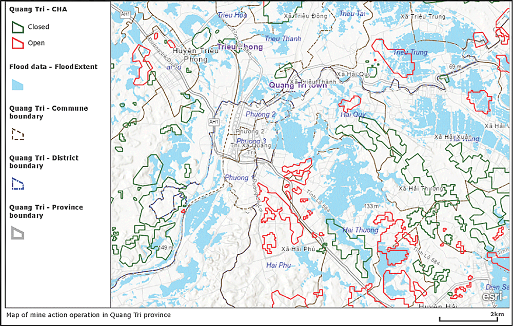
Figure 3. Mapping of CHAs and satellite-detected surface water following the October 2020 storms across Quảng Trị Province.
Figure courtesy of Sentinel-1 image, 29 October 2020, 05:43 local time, UNITAR and PTVN.
IMAS 07.13 (Environmental Management),25 IMAS 07.14 (Risk Management),26 and IMAS 08.10 (Non-Technical Survey)27 could potentially be updated to include guidance on the assessment and management of climate change impacts. IMAS 07.13 primarily addresses the mine action sector’s responsibility to prevent and mitigate possible adverse impacts on the environment caused by field operations. However, IMAS 07.13 does not yet consider how environmental hazards—due to climate change—will impact mine action operations or what measures should be considered to reduce the effects of climate change on vulnerable communities once land has been cleared and released.
IMAS 07.14 is designed to ensure the effective management and reduction of risks relating to mine action operations, critically requiring risk management systems to adapt quickly to changing internal and external circumstances. Early accounting for climate change risks would help mine action organizations to better allocate resources and prioritize operations, thereby avoiding other incurred costs or the duplication of work. Residual risk management practices and plans should also consider the implications of future climate change–related hazards, the impact this might have for the recontamination of previously cleared land, and the risk of exacerbating climate change impacts due to the intended future use of land once it has been released.
IMAS 08.10 sets out guidance for NTS and the collection of data on the physical environment, which is relevant for supporting prioritization planning and developing work plans. As a minimum, NTS should collect information on previous adverse weather events and environmental hazards as reported by local communities, environmental NGOs, or local authorities to improve prioritization strategies and preparedness measures.
While IMAS and technical guidance are important for steering best practices for mine action organizations, national mine action authorities (NMAA) or mine action operators can act by reviewing and updating current practices and operating procedures. Incorporating climate change-related hazards and risk management into national mine action strategies and NMAS should be a priority. Since there is no central database of national strategies or NMAS, it is difficult to determine the current gaps. However, steps are being taken by some.
The development of a NMAS on environmental management in Cambodia, in accordance with their National Mine Action Strategy 2018–2025,28 highlights operational challenges and unpredictability due to climate change. Challenges are also described in the National Mine Action Strategic Plan 2016-2020 for Afghanistan, including the effects from melting snow on steep slopes, flooding, and landslides.29 Vietnam is also developing a new NMAS, which is set to include consideration of climate change-related risks in TS operations.
Predicting And Planning for Change
Dealing With Uncertainty
The uncertainty around climate change-related risks and how these will regionally impact mine action operations makes it difficult to prioritize and plan for mitigation measures. This uncertainty presents key challenges for HMA organizations, including how to measure the vulnerability of operating systems, levels of exposure, and costs associated with risk management strategies.30 Achieving efficient and effective climate change risk management requires all stakeholders to have an understanding of the multiplicity of uncertainties presented and for these uncertainties to be fully considered.31
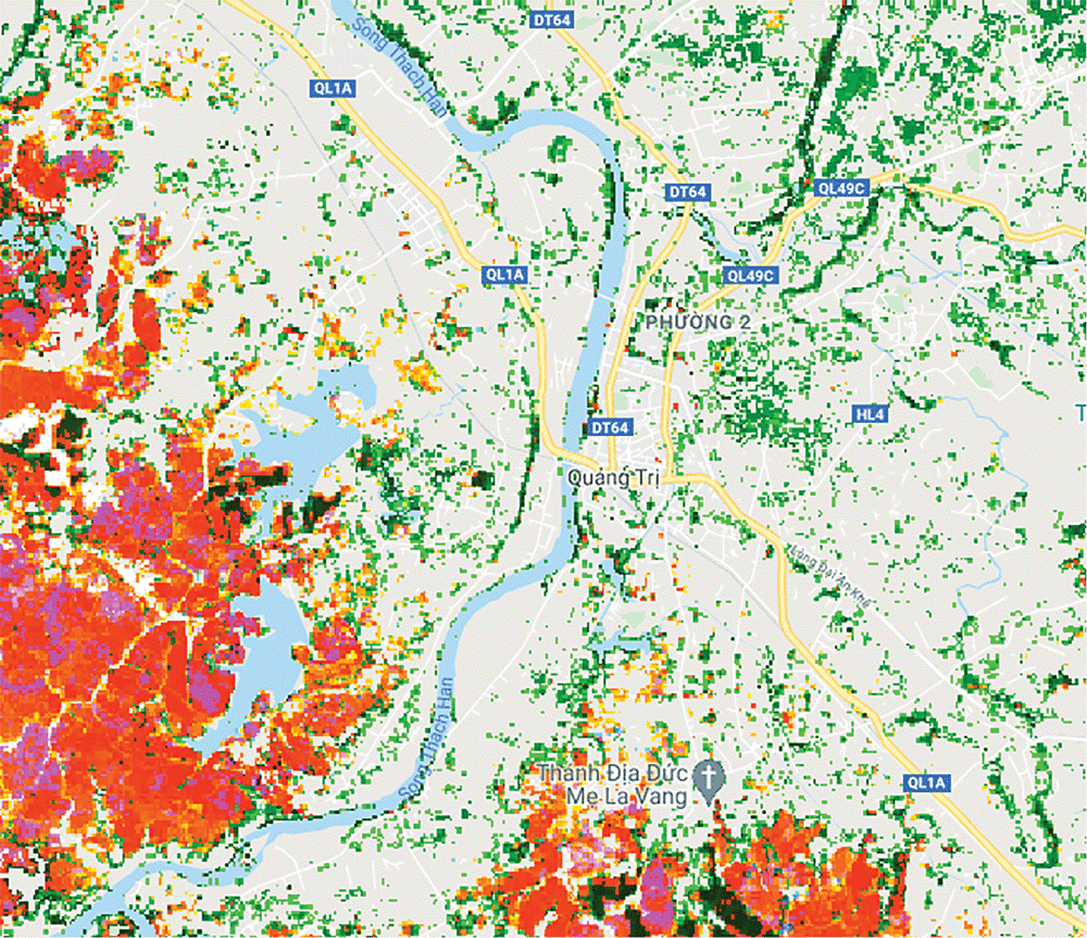
Figure 3. Mapping of CHAs and satellite-detected surface water following the October 2020 storms across Quảng Trị Province. Figure courtesy of Sentinel-1 image, 29 October 2020, 05:43 local time, UNITAR and PTVN.
In many countries, detailed climate modelling is absent or incomplete. Due to the complexities of weather patterns, reasonable climate change projections and potential hazards are often difficult to predict. Data on historical weather patterns and improved awareness of local climate trends could support planning, but this may be challenging for international organizations working in varied contexts. Collecting this data during NTS could be a simplified, first step to address this problem. This would help identify current exposure and vulnerability but not necessarily future exposure.
Further, participatory approaches to the prioritization of land clearance could address some uncertainty on climate change-related hazards and risks, by engaging with local communities—especially those most marginalized (including women, children, and people with disabilities)—local authorities, partners, and organizations working on climate and disaster preparedness.
Mapping Vulnerable Areas
Using existing data on climate change–related hazards and their relationship with mine action programs is an important tool to raise awareness across affected communities and the mine action sector. An example of a simple measure is given in Figure 3, where open-source satellite data and detected surface water following the tropical storms across Quàng Trị Province has been overlaid onto maps showing CHAs for EO. Although this gives just a snapshot in time, Figure 3 shows where flood water has impacted CHAs. Combined with elevation data and an understanding of where surface water has and will flow, it could alert communities to potential risks, as well as inform programming and work plan decisions.
Environmental Data Sources
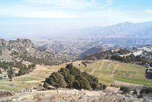
Open-source environmental data can also inform climate change adaptation planning. Earth Map was developed by Google and the UN Food and Agriculture Organization (FAO), and launched in 2020.32 Earth Map gives free access to a wide range of climate and environmental data—including rainfall, temperature, elevation, slope gradients, vegetation cover, deforestation, and changes in surface water occurrence—which can be used to build an understanding of the local and regional environmental conditions. Data on deforestation (see Figure 4) is valuable to understand both the potential risks to mine action operations—e.g., increased surface water runoff and the increased risk of slope failures and landslides—and the importance of aligning post-clearance land use with sustainable practices.
Lessons From Disaster Risk Reduction and Climate Change Adaptation Planning
Climate change adaptation and disaster risk reduction mainstreaming has been slowly incorporated into the development sector since the 1990s. Both the United Nations Development Programme (UNDP) and the United Nations Environment Programme (UNEP) support knowledge-sharing platforms on climate change adaptation, including the Global Adaptation Network (GAN), which serves to link organizations around the world.33 Climate change adaptation is cross-disciplinary, and the mine action sector will need to engage with regional organizations and authorities undertaking climate vulnerability assessments and climate scenario planning. The NDC Partnership website also hosts a platform to search country level climate progress and information on the focal point for in-country engagement.34 Engagement is important to ensure that the mine action sector can build resilience.
ThinkHazard! is another web-based tool that was developed to support non-specialists in considering the impacts of natural disasters on projects.35 ThinkHazard only provides high-level guidance for a region but gives a general overview of potential hazards, highlighting how these may change in the future as a result of climate change. The Red Cross Red Crescent Climate Centre also provides guidance on simple climate change adaptation actions and has produced climate factsheets for some countries, detailing regional climate change projections.36
With limited guidance currently in place for the mine action sector, the introduction of climate change adaptation principles must be supported. This would have the potential to reduce future impacts on operations, improve the efficacy of current work, and help build climate resilience for communities.
Conclusions and Recommended Next Steps
Incorporating climate change–related risk assessments into existing prioritization strategies is key. This would require the coordination of NMAA with country-level adaptation planning by local governments and initial evaluations of whether CHAs or suspected hazardous areas (SHAs) containing EO are within climate vulnerable areas. This includes areas prone to fluvial or surface-water flooding, areas close to slopes susceptible to collapse, or where there have been high rates of deforestation. These areas may need to be prioritized for clearance, if they are deemed at risk to the unpredictable effects of climate change. Delaying clearance introduces the risk that these areas may be more difficult and costly to clear in the future and presents additional hazards to the local community. Alternatively, prioritization of an area may be needed to facilitate the implementation of a climate adaptation scheme (e.g., catchment management or flood alleviation) considered of high benefit to the community.
Awareness Raising
No sector is immune to the effects of climate change. Awareness raising is needed to inform mine action operators, mine action authorities, donors, and affected communities on the relationship between EO and climate change risks. This is especially important for traditional HMA donors. Awareness must be raised about the benefit of funding HMA, which aligns with climate adaptation measures designed to support local communities as part of post-clearance land use.
Good Practice Guidance
As well as incorporating climate change and risk management into national mine action strategies, development of a new IMAS specifically to address climate change risks and adaptation planning is recommended, with cross reference to other relevant IMAS (such as 07.13, 07.14, 08.10, 08.20). A new IMAS should include guidance on the identification of current and future climate vulnerabilities assessment of climate risks, identification of adaptation options, implementation, and monitoring and review.
Climate Data, Climate Projections, and Early-Warning Systems
Historic climate data and knowledge of regional climate trends can be a first step in better understanding the current climate change risks. As well as collaborating with regional authorities, information on climate change risks should be collected and evaluated as early as possible, with community engagement on climate change forming part of the NTS and CL process. In some cases, it may be necessary to monitor severe weather events and develop an early warning system where increased risks to local communities are possible.
Collaboration and Strengthening Community Resilience to Climate Change
Aligning HMA with community-led climate change adaptation initiatives on land cleared of EO will provide multiple benefits and help to support more sustainable livelihoods. Without an aligned approach, there is a risk of further degradation of already marginal land. From the onset, early partnerships between HMA, environmental authorities, and local climate adaptation organizations are recommended to facilitate an improved approach.
Even before the COVID-19 pandemic, the estimated shortfall in HMA funding was US$1 billion—only 0.4 percent of overseas aid is allocated to mine action. This shortfall will likely increase with further budgetary pressures on donors. This means that comprehensive approaches to HMA have even greater importance, where donors can foresee multiple benefits such as linking HMA with climate adaptation for local communities.
As McCosker from NPA noted
“It comes down to a question of priorities, in terms of whether we look at the immediate threat, which is people being unable to farm or use their land because of the continuing impact of explosive ordnance. Or, do we look at the longer-term threat where they might not be able to use their land in the way that they want to because of climate change impacts?“
Ultimately, as McCosker also noted, a balance between the short- and longer-term objectives is needed. This must be clearly communicated to donors and support must be afforded by the mine action sector and local stakeholders. Due to the intimate relationship with the environment and HMA’s goal to support local communities, there is an opportunity to achieve both and to ensure communities can adapt to future and current climate change challenges.
Acknowledgements
The authors are grateful for the input and comments provided by Phạm Hoàng Hà, Country Director of PTVN; Kimberley McCosker, Project Manager for NPA Vietnam; and Bui Doan Bach, Environment Protection Officer for NPA Vietnam.
Linsey Cottrell
Environmental Policy Officer
Conflict and Environment Observatory
 Linsey Cottrell is the Environmental Policy Officer at the UK-based charity Conflict and Environment Observatory (CEOBS). Cottrell is a Chartered Environmentalist and registered in the UK as a Specialist in Land Condition. She is also a trustee for the Institution of Environmental Sciences. Before joining CEOBS in 2019, she worked in the environmental consultancy sector on contaminated land and environmental risk assessment.
Carlie Stowe
Project Manager
PeaceTrees Vietnam
 Carlie Stowe is the Project Manager and Environmental Policy lead for PeaceTrees Vietnam. Stowe is also a research assistant for the climate change adaptation and resilience team at the London School of Economics and Political Science (LSE) Grantham Research Institute. She holds a master’s from LSE in International Development and Humanitarian Emergencies and has worked in the mine action sector since 2018.