
$700,000 grant funds virtual geoscience education project
News
There's no substitute for studying geology in the field, but when it takes 80 million years for mountains to form and when it's not possible to travel halfway around the world to see something firsthand, then a good computer simulation can be helpful.
That's the idea behind a new set of Google Earth tools being developed by Dr. Steven Whitmeyer, associate professor of geology and environmental science, and colleagues at Old Dominion University and Northern Virginia Community College. Whitmeyer received a $700,000 grant from the National Science Foundation for his part. Researchers at the other colleges, Declan De Paor at ODU and Callan Bentley at NVCC, also received grants.
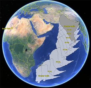
"One of the things I have been interested in is using Google Earth to show time-based processes that you couldn't illustrate particularly well without this," said Whitmeyer as he showed an animation he created that depicts the India Subcontinent moving from the southern hemisphere into its current position to form the Himalayas. The next step, which students will help create, is an animation showing the breakup of Pangaea, a supercontinent that formed about 300 million years ago and started breaking apart 200 million years ago.
Whitmeyer has been working on educational models using Google Earth for the past five years. This project, Google Earth for Onsite and Distance Education, or GEODE for short, is the next step in the development process. "Each project has been a little different. It has to be original, but it can build off earlier work," said Whitmeyer, who presented the GEODE concept with DePaor and Bentley at the 2013 Geological Society of America conference in Denver in October.
Another important aspect of the project is to create a virtual fieldwork environment where students can "visit" different areas around the globe to do research. For example, students can pick out specimens native to a region and get information and 3-D images. "So you can go to South Africa and have a specimen of the rock that you would see there and if you click on it, you get information about it, geochemistry and that sort of stuff," said Whitmeyer.
The virtual fieldwork environment also will benefit people who have disabilities that prevent them from working in the field. "It doesn't replace fieldwork, but you also have to recognize that there are some things that you can illustrate with virtual visualizations in something like Google Earth pretty well and you don't want to disenfranchise that part of the community that's not able to do these outside field trips."
Networking with other students and researchers is another important aspect of GEODE, which will have its own website that will be available to the general public as well. Whitmeyer said De Paor describes the networking environment as a reverse massive open online course, or MOOC, where rather than having one instructor and legions of students, there can be one student tapping an array of faculty who are experts in different areas and all contributing to GEODE.
Another feature will enable GEODE users to create their own tools and modules. "We want to set this up so other people can design their own stuff," Whitmeyer said. "We will be expanding on our set of tools to help people who aren't quite as savvy for designing things in Google Earth to help them do it."
For now, the work that has been done with the earlier grants is available at DigitalPlanet.org (http://www.digitalplanet.org/site/Home.html) and at Whitmeyer's website. Content could start showing up on geode.net by the end of January 2014.