
GS Students Help Improve Carrier WiFi

SUMMARY: A great example of GIS research that directly impacted campus was the work of GS students Brennan Deal ('17) and Ryan Allen ('18), whose project measuring the WiFi strength in Carrier Library was used to improve the number of access points in the building.
By: Daniel Vieth, Creative Services
Though we may not realize it, geographic information systems (GIS) play a major role in our lives. GIS, or the process of mapping and visualizing data, is used in nearly every industry, with outcomes ranging from where the next Starbucks should be located, to helping improve the internet speed in a building. The versatility and applicability of this field can be seen at JMU with the work being done in the Geographic Science (GS) major. A great example of GIS research that directly impacted campus was the work of GS students Brennan Deal (‘17) and Ryan Allen (‘18), whose project measuring the WiFi strength in Carrier Library was used to improve the number of access points in the building.
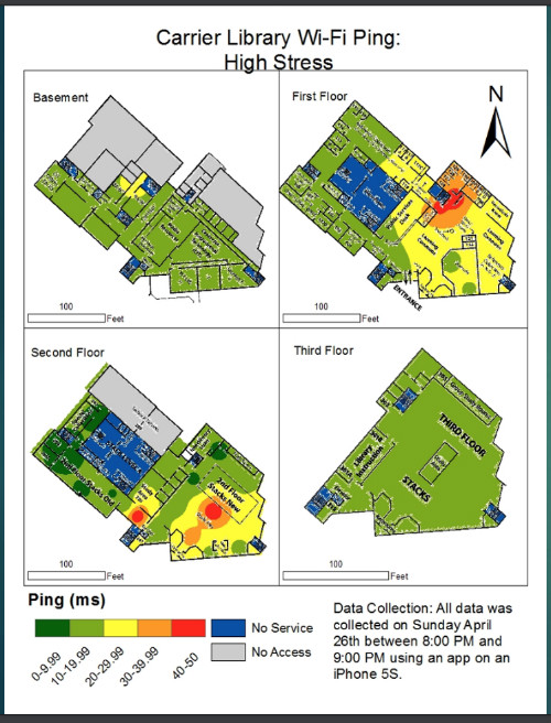
Allen and Deal conducted this research as the final class project for their GS 215 course. “I had done a little WiFi work in the past through the GeoSpatial Semester program, so I was trying to see if there was any way to apply that here,” explained Allen. “We figured a lot of other people were frustrated and experienced issues with the WiFi at Carrier, so we thought this could be a good project to give back to the community.” To accomplish this, the students collected signal strength data from hundreds of points in Carrier during high and low “stress” times using the SpeedTest phone app. The students then created hotspot maps that showed the differences in bandwidth and “ping,” or connection rate, between the high and low stress periods. “Basically our assumptions were right,” said Deal. “During high stress days, the WiFi was pretty bad, and on low stress days the WiFi had a faster connection, but unfortunately wasn’t significantly better.”
Unknown to the students, Carrier Library was already planning to improve their WiFi. “We had a building task force, and one of the things that came out was that we don’t have the right technology in the building anymore,” said Kathy Clarke, a librarian and Interim Director of Assessment and Planning at Carrier. “We were working on how to rewire a building that was built in 1929, and trying make it effective for a 2016 student.” When the task force heard about the student’s project, they asked for a copy of the students’ findings. “We took our final project to David Vess [the Digital User Experience Librarian at Carrier], and they used it to update the router locations in Carrier,” said Allen.
With the information provided by the students, and project money from the university, JMU’s Network Services worked with library technical personnel to wire and install an additional 78 network access points over winter break, making a total of 97 routers in Carrier. “That’s about five times more than was previously in the building,” said Bill Hartman, the Interim Director of Digital Services and Systems Administrator at Carrier. According to Clarke, there has since been a significant decline in complaints and students “clumping” around the wireless access points. “The students probably don’t notice, and that’s okay, that was our goal,” she continued. “We want WiFi to be as available to them as much as possible."
As the students found, projects like this demonstrate the versatility of GIS and geographic science. “The geographic perspective can be applied to pretty much anything. There’s not really a field that GS can’t be applied to,” said Allen. “This project gave us a brief insight into the capabilities and extent in which we can expand our horizon.” Just some examples from the students included another project they had worked on measuring the amount of light on campus in relation to safety, and future ideas of analyzing the use of space in Carrier or measuring the WiFi in other buildings. “I chose to become a GS major because I wanted something where, if I wanted to, I could work with the environment, or with the government, or with food and security in a third world country,” said Deal. “It’s a very versatile field, where you can extend your skills out to literally anywhere.”
“This project was the perfect blend of what we do,” added Clarke. “This was an opportunity to not only help us do something that needed to be done, but also help the students with their project.” Clarke encourages every department on campus to think about the ways that GIS can improve the experiences of students, faculty, and staff on campus. “I just wanted to say thank you to those two students,” Clarke continued. “They saved us an enormous amount of time, helped us make an argument to the university to fund this, and in turn they improved the experiences for students on this campus.”